IMAGES TAKEN NEAR TO
Ashley Gardens, ORPINGTON, BR6 9NH
Introduction
This page details the photographs taken nearby to Ashley Gardens, BR6 9NH by members of the Geograph project.
The Geograph project started in 2005 with the aim of publishing, organising and preserving representative images for every square kilometre of Great Britain, Ireland and the Isle of Man.

There are currently over 7.5m images from over14,400 individuals and you can help contribute to the project by visiting https://www.geograph.org.uk
Image Map
Images are licensed for reuse under creativecommons.org/licenses/by-sa/2.0
Notes
- Clicking on the map will re-center to the selected point.
- The higher the marker number, the further away the image location is from the centre of the postcode.
Image Listing (52 Images Found)
Images are licensed for reuse under creativecommons.org/licenses/by-sa/2.0
Image
Details
Distance
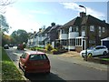
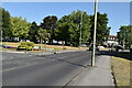
2
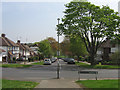
Haywood Rise
Part of the central axis of symmetry of what is known as the Davis Estate, after its builders.
Image: © Ian Capper
Taken: 21 Apr 2009
0.05 miles
6
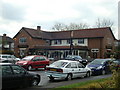
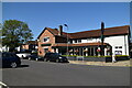
The Buff Public House, Green Street Green
Image: © Stacey Harris
Taken: 28 Mar 2009
0.06 miles
8
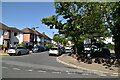
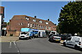
Crescent Way
Shopping parade alongside Sevenoaks Road. For closeup of Coal Tax Post no 195, visible to the left of the photo, see Image
Image: © Ian Capper
Taken: 13 Feb 2009
0.08 miles
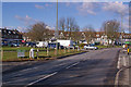
10
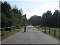
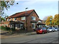
Shire Lane
This lane leads from Sevenoaks Road. It is used by council vehicles only heading towards a depot works.
It passes by the 'Green' of Green Street Green.
Image: © David Anstiss
Taken: 31 Jul 2011
0.08 miles