IMAGES TAKEN NEAR TO
Repton Road, ORPINGTON, BR6 9HS
Introduction
This page details the photographs taken nearby to Repton Road, BR6 9HS by members of the Geograph project.
The Geograph project started in 2005 with the aim of publishing, organising and preserving representative images for every square kilometre of Great Britain, Ireland and the Isle of Man.

There are currently over 7.5m images from over14,400 individuals and you can help contribute to the project by visiting https://www.geograph.org.uk
Image Map
Images are licensed for reuse under creativecommons.org/licenses/by-sa/2.0
Notes
- Clicking on the map will re-center to the selected point.
- The higher the marker number, the further away the image location is from the centre of the postcode.
Image Listing (45 Images Found)
Images are licensed for reuse under creativecommons.org/licenses/by-sa/2.0
Image
Details
Distance
1
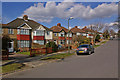
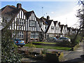
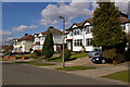
Cheltenham Road
One of a number of roads in southeast Orpington named after public schools. Cheltenham Road links Repton Road and Charterhouse Road, the latter just visible in the background.
Image: © Ian Capper
Taken: 15 Mar 2010
0.07 miles
2
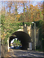
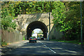
Railway bridge over Sevenoaks Road, Orpington
This is where the South Eastern main line crosses Sevenoaks Road, as the railway climbs up from Orpington Station towards Chelsfield and Polhill Tunnels, where it cuts through the North Downs. Although it is generally thought of as a bridge, it could almost be defined as a "cut and cover" tunnel, given the amount of embankment above it, and the maturity of the trees growing there. The scale of it can be seen from the person about to work through it, on the left of the picture.
Image: © Ian Capper
Taken: 9 Nov 2007
0.08 miles
4
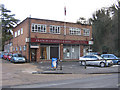
Francis Chappell and Sons Funeral Directors
On Sevenoaks Road next to where it goes under the Southeastern main railway line.
Image: © Ian Capper
Taken: 12 Feb 2009
0.08 miles
5
Railway bridge over Sevenoaks Road
The railway is the main line to Tonbridge and points east.
Image: © Robin Webster
Taken: 27 Sep 2011
0.09 miles
6
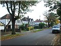
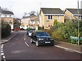
Repton Road
One of a number of roads in southeast Orpington named after public schools.
Image: © Ian Capper
Taken: 12 Feb 2009
0.10 miles
7
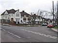
Cheltenham Road
One of a number of roads in southeast Orpington named after public schools, seen here at its junction with Charterhouse Road.
Image: © Ian Capper
Taken: 11 Feb 2009
0.12 miles
8
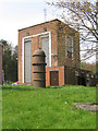
Orpington Pumping Station
Operated by Thames Water. Although the River Cray rises from springs in Priory Gardens (see Image), the head of the valley is much further south, and in the past the High Street through Orpington would periodically flood. Now water extraction at this site would seem to make this far less likely, if not impossible. A pumping station has stood here since 1880, with the original one built by the West Kent Water Company.
Image: © Ian Capper
Taken: 22 Apr 2008
0.12 miles
9
Helegan Close
Part of the development of much of the Orpington Hospital site (see Image), the majority of road names having a Cornish theme.
Image: © Ian Capper
Taken: 12 Feb 2009
0.13 miles
10
Sandhurst Road
This is a slight exception to the roads in this part of Orpington, which are generally named after public schools, which Sandhurst is not, even if it is still an educational establishment. This bottom section of the road, with the three semis seen here, has a different character from the upper section - see Image
Image: © Ian Capper
Taken: 15 Mar 2010
0.13 miles