IMAGES TAKEN NEAR TO
Goddington Lane, ORPINGTON, BR6 9DY
Introduction
This page details the photographs taken nearby to Goddington Lane, BR6 9DY by members of the Geograph project.
The Geograph project started in 2005 with the aim of publishing, organising and preserving representative images for every square kilometre of Great Britain, Ireland and the Isle of Man.

There are currently over 7.5m images from over14,400 individuals and you can help contribute to the project by visiting https://www.geograph.org.uk
Image Map (Loading...)


Getting Data...Please wait
Leaflet Map data © OpenStreetMap
Images are licensed for reuse under creativecommons.org/licenses/by-sa/2.0
Notes
- Clicking on the map will re-center to the selected point.
- The higher the marker number, the further away the image location is from the centre of the postcode.
Image Listing (37 Images Found)
Images are licensed for reuse under creativecommons.org/licenses/by-sa/2.0
Image
Details
Distance
1
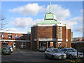
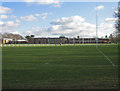
St Olave's Grammar School
St Olave's School was originally founded in 1571, occupying various sites in Southwark over the years. In 1967 it amalgamated with St Saviour's Grammar School, itself founded in 1562, and moved to this site on the outskirts of Orpington. It is now one of the top ranking Grammar Schools in the country, with a strong sporting and musical reputation, as well as academic.
Image: © Ian Capper
Taken: 30 Jan 2008
0.06 miles
2
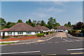
St Margaret's Close
A cul de sac of 1950s bungalows off Charterhouse Road.
Image: © Ian Capper
Taken: 22 May 2012
0.08 miles
3
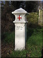
Coal Tax Post no 198
This Coal Tax Post (no 198 in the list linked to below) is in Goddington Lane.
Grade II listed - for listing particulars, see www.historicengland.org.uk/listing/the-list/list-entry/1299017.
Image: © Ian Capper
Taken: 30 Jan 2008
0.08 miles
4
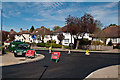
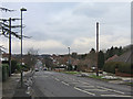
Charterhouse Road
Charterhouse Road at its junction with Haileybury Road (in the foreground), while being reurfaced.
Image: © Ian Capper
Taken: 6 Apr 2011
0.09 miles
5
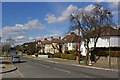
Charterhouse Road
One of a number of roads in southeast Orpington named after public schools. This is the section of Charterhouse Road between Haileybury Road (in the foreground) and Cheltenham Road.
Image: © Ian Capper
Taken: 15 Mar 2010
0.09 miles
6
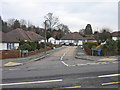
St Margaret's Close
A short cul-de-sac off Charterhouse Road.
Image: © Ian Capper
Taken: 11 Feb 2009
0.10 miles
7
Charterhouse Road
One of a large number of roads in southeast Orpington named after public schools.
Image: © Ian Capper
Taken: 11 Feb 2009
0.10 miles
9

Charterhouse Road - resurfacing
Resurfacing work on Charterhouse Road, one of a number of roads in this part of Orpington named after public schools.
Image: © Ian Capper
Taken: 6 Apr 2011
0.10 miles
10
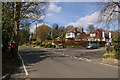
Junction of Goddington Lane with Wyvern Close
Goddington Lane was before the development of this area an old country lane, already shown on early 19th century maps. In the background on the left can be seen a Coal Tax Post (see Image).
Image: © Ian Capper
Taken: 15 Mar 2010
0.11 miles