IMAGES TAKEN NEAR TO
Avalon Close, ORPINGTON, BR6 9BS
Introduction
This page details the photographs taken nearby to Avalon Close, BR6 9BS by members of the Geograph project.
The Geograph project started in 2005 with the aim of publishing, organising and preserving representative images for every square kilometre of Great Britain, Ireland and the Isle of Man.

There are currently over 7.5m images from over14,400 individuals and you can help contribute to the project by visiting https://www.geograph.org.uk
Image Map (Loading...)


Getting Data...Please wait
Leaflet Map data © OpenStreetMap
Images are licensed for reuse under creativecommons.org/licenses/by-sa/2.0
Notes
- Clicking on the map will re-center to the selected point.
- The higher the marker number, the further away the image location is from the centre of the postcode.
Image Listing (20 Images Found)
Images are licensed for reuse under creativecommons.org/licenses/by-sa/2.0
Image
Details
Distance
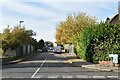
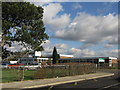
3
Avalon Road at the junction of Chelsfield Lane
Chelsfield Road is the last suburban road on the edge of London here, you can just see the countryside behind the houses.
Image: © David Howard
Taken: 12 Feb 2012
0.12 miles
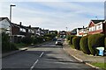
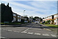
4
Burwood School
A school for pupils between the ages of 10 to 16 with emotional and behavioural difficulties. In Avalon Road (a number of other roads in the area have Arthurian names)
Image: © Ian Capper
Taken: 6 Feb 2008
0.12 miles
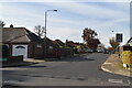
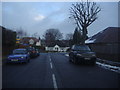
7
Chelsfield Lane, Goddington
These are the last houses in London, beyond is the open countryside although Kent county itself is around a mile beyond to the east.
Image: © David Howard
Taken: 12 Feb 2012
0.15 miles
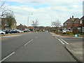
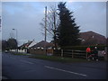
8
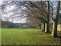
Goddington Park
Goddington Park is an informal park situated between Orpington and Chelsfield. On the right are the back gardens of houses in Avalon Road whilst the houses ahead are in Berrylands.
Image: © Marathon
Taken: 16 Dec 2012
0.16 miles