IMAGES TAKEN NEAR TO
Pine Glade, ORPINGTON, BR6 8NT
Introduction
This page details the photographs taken nearby to Pine Glade, BR6 8NT by members of the Geograph project.
The Geograph project started in 2005 with the aim of publishing, organising and preserving representative images for every square kilometre of Great Britain, Ireland and the Isle of Man.

There are currently over 7.5m images from over14,400 individuals and you can help contribute to the project by visiting https://www.geograph.org.uk
Image Map
Images are licensed for reuse under creativecommons.org/licenses/by-sa/2.0
Notes
- Clicking on the map will re-center to the selected point.
- The higher the marker number, the further away the image location is from the centre of the postcode.
Image Listing (65 Images Found)
Images are licensed for reuse under creativecommons.org/licenses/by-sa/2.0
Image
Details
Distance
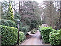
1
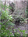
Pond north of Beech Dell, BR2
The water flows northwards into the Image
Image: © Mike Quinn
Taken: 11 Jan 2011
0.11 miles
3
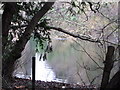
Lake south of the A232 west of Farnborough Common
Water flows northwards into this lake through Ninhams Wood from Image - see the satellite image http://wtp2.appspot.com/wheresthepath.htm?lat=51.361545252210135&lon=0.04677772521972656&gz=15&oz=9>=1. But it is not clear where it flows northwards - possibly into the lake next to The Spinney in TQ4365 - see the satellite image http://wtp2.appspot.com/wheresthepath.htm?lat=51.36977104257854&lon=0.05261421203613281&gz=16&oz=9>=1; this must feed the East Branch of the River Ravensbourne.
Image: © Mike Quinn
Taken: 11 Jan 2011
0.12 miles
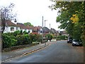
4
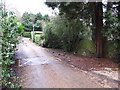
Beech Dell, BR2
The speed hump, and the low humped brick wall and trellis fencing to its right, mark where a stream crosses (underneath) the road. See Image
Image: © Mike Quinn
Taken: 11 Jan 2011
0.13 miles
5
Beech Dell, BR2 (2)
Image: © Mike Quinn
Taken: 11 Jan 2011
0.13 miles
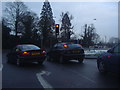
7
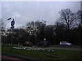
Junction of Croydon Road and Farnborough Common
Image: © David Howard
Taken: 8 Apr 2012
0.13 miles
8
Stream feeding the Ravensbourne/Quaggy system, south of Beech Dell, BR2 (4)
Image: © Mike Quinn
Taken: 11 Jan 2011
0.14 miles
9
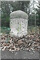
Old Milestone by A21, Farnborough Common, Locks Bottom, 130m West of Fantail junction
The Milestone is located on edge of shrubbery, behind path on the North of the road. Parish of Bromley (Bromley District). Metal plate attached to stone post, Bromley marker design, erected by the Sevenoaks turnpike trust in the 19th Century. An earlier photograph can be found here: https://www.geograph.org.uk/photo/6061421
Inscription reads:-
(1 / MILE / TO / FARNBORO) : : (13 / MILES / TO / LONDON /BRIDGE)
Grade II listed. List Entry Number: 1299025 https://historicengland.org.uk/listing/the-list/list-entry/1299025
Milestone Society National ID: KE_LBFA13
Image: © Andrew Knorpel
Taken: 1 Jan 2023
0.16 miles
10

Old Milestone by the A21, Farnborough Common, Bromley parish
Metal plate attached to stone post by the A21, in parish of BROMLEY (BROMLEY District), Farnborough Common, Locks Bottom, 130m West of Fantail junction, on edge of shrubbery, behind path, on Northeast side of road. Bromley marker, erected by the Sevenoaks turnpike trust in the 19th century.
Inscription reads:-
: 1 / MILE / TO / FARNBORO : : 13 / MILES / TO / LONDON /BRIDGE :
Grade II listed.
List Entry Number: 1299025 https://historicengland.org.uk/listing/the-list/list-entry/1299025
Milestone Society National ID: KE_LBFA13.
Image: © C Woodward
Taken: 16 Mar 2007
0.16 miles