IMAGES TAKEN NEAR TO
Grange Road, ORPINGTON, BR6 8EB
Introduction
This page details the photographs taken nearby to Grange Road, BR6 8EB by members of the Geograph project.
The Geograph project started in 2005 with the aim of publishing, organising and preserving representative images for every square kilometre of Great Britain, Ireland and the Isle of Man.

There are currently over 7.5m images from over14,400 individuals and you can help contribute to the project by visiting https://www.geograph.org.uk
Image Map (Loading...)


Getting Data...Please wait
Leaflet Map data © OpenStreetMap
Images are licensed for reuse under creativecommons.org/licenses/by-sa/2.0
Notes
- Clicking on the map will re-center to the selected point.
- The higher the marker number, the further away the image location is from the centre of the postcode.
Image Listing (59 Images Found)
Images are licensed for reuse under creativecommons.org/licenses/by-sa/2.0
Image
Details
Distance
1
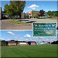
Newstead Wood School, Orpington, BR6
A selective girls' school in the London Borough of Bromley; see http://www.newsteadwood.bromley.sch.uk/
Image: © Philip Talmage
Taken: 17 Sep 2005
0.04 miles
2
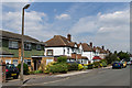
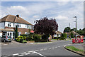
Grange Road
Mainly 1940s/50s(?) housing. The road name refers to a large house, Crofton Grange, situated near the junction of Crofton Road and Crofton Avenue, although much of the road had been developed by the time the Grange itself was demolished in around 1953.
Image: © Ian Capper
Taken: 8 Aug 2013
0.05 miles
3
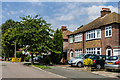
Broughton Road
1940s/50s(?) housing in an area between Crofton Road and Crofton Avenue.
Image: © Ian Capper
Taken: 8 Aug 2013
0.06 miles
4
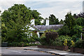
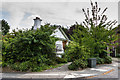
The Lodge
Former lodge to the now demolished Crofton Hall, situated in Crofton Avenue. Dating from c.1860, it is grade II listed - see www.historicengland.org.uk/listing/the-list/list-entry/1068864.
Image: © Ian Capper
Taken: 8 Aug 2013
0.07 miles
5
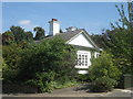
The Lodge
Former lodge to the now demolished Crofton Hall, situated in Crofton Avenue. Dating from c.1860, it is grade II listed - see www.historicengland.org.uk/listing/the-list/list-entry/1068864.
Image: © Ian Capper
Taken: 8 Aug 2013
0.08 miles
6
The Lodge, Crofton
Grade II Listed building on Crofton Avenue.
See http://www.britishlistedbuildings.co.uk/en-358419-the-lodge-35-bromley for more details about the building.
Image: © David Anstiss
Taken: 31 Jul 2011
0.08 miles
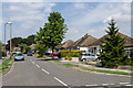
7
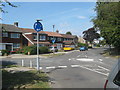
Roundabout on Crofton Avenue
Crofton Avenue leads from Rusland Avenue towards Crofton Road.
Lovibonds Avenue heads left towards Darrick Wood schools.
Image: © David Anstiss
Taken: 31 Jul 2011
0.10 miles
8
Torver Way
1940s/50s(?) housing in an area between Crofton Road and Crofton Avenue.
Image: © Ian Capper
Taken: 8 Aug 2013
0.11 miles
9
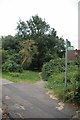
The London Loop Enters Crofton Avenue
The long distance path http://www.walklondon.org.uk/route.asp?R=5 exits Image nature reserve
and enters suburbia.
Image: © Glyn Baker
Taken: 21 Aug 2012
0.12 miles
10
Foxfield Road
1940s/50s(?) bungalows in an area between Crofton Road and Crofton Avenue.
Image: © Ian Capper
Taken: 8 Aug 2013
0.13 miles