IMAGES TAKEN NEAR TO
Arden Grove, ORPINGTON, BR6 7WD
Introduction
This page details the photographs taken nearby to Arden Grove, BR6 7WD by members of the Geograph project.
The Geograph project started in 2005 with the aim of publishing, organising and preserving representative images for every square kilometre of Great Britain, Ireland and the Isle of Man.

There are currently over 7.5m images from over14,400 individuals and you can help contribute to the project by visiting https://www.geograph.org.uk
Image Map (Loading...)


Getting Data...Please wait
Leaflet Map data © OpenStreetMap
Images are licensed for reuse under creativecommons.org/licenses/by-sa/2.0
Notes
- Clicking on the map will re-center to the selected point.
- The higher the marker number, the further away the image location is from the centre of the postcode.
Image Listing (47 Images Found)
Images are licensed for reuse under creativecommons.org/licenses/by-sa/2.0
Image
Details
Distance
1
Bassetts House
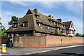
Part of Bassetts Campus, a former residential facility for people with learning difficulties operated by Bromley PCT in Broadwater Gardens, on the site of Starts Hill Farm. Bassetts House itself, which latterly served as the headquarters for Bromley PCT, stands at the junction of Broadwater Gardens and Starts Hill Road. It was built in 1911 to a design of the architects Sir Aston Webb and his son Maurice Webb and is locally listed.
The facility closed in November 2013 and the site has been sold for development, with Bassetts House itself due to be converted into apartments.
Image: © Ian Capper
Taken: 3 Jun 2013
0.11 miles
2
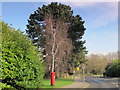
Broadwater Gardens, BR6
Shows the location of Image
Image: © Mike Quinn
Taken: 9 Feb 2011
0.12 miles
3
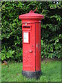
George VI postbox, Broadwater Gardens, BR6
Image: © Mike Quinn
Taken: 9 Feb 2011
0.12 miles
4
Broadwater Gardens / Starts Hill Road, BR6
Shows the location of Image
Image: © Mike Quinn
Taken: 9 Feb 2011
0.13 miles
5
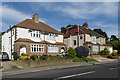
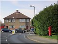
Starts Hill Road
1930s semis in Starts Hill Road.
Image: © Ian Capper
Taken: 3 Jun 2013
0.14 miles
6
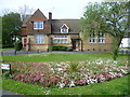
Houses next to The Green at Farnborough
It is difficult to put a date on these houses facing on to the A21 and next to The Green at Farnborough. It looks though like it might have once been a school.
Image: © Marathon
Taken: 23 Apr 2014
0.15 miles
8
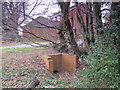
Culvert for a minor tributary of the Kyd Brook, Darrick Wood
Image: © Mike Quinn
Taken: 9 Feb 2011
0.15 miles
9
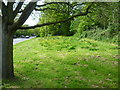
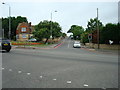
The Green at Farnborough Common
The A21 (Farnborough Common) is on the left and this small triangular remnant of Farnborough Common is just beyond Farnborough High Street. The main part of what is left of Farnborough Common is further up the A21 in the triangle formed by the A232 (Croydon Road) and Hollydale Drive.
Image: © Marathon
Taken: 23 Apr 2014
0.16 miles
10
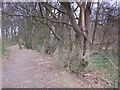
Footpath in Darrick Wood
The course of a minor tributary of the Quaggy River runs to the right of the line of trees.
Image: © Mike Quinn
Taken: 9 Feb 2011
0.17 miles