IMAGES TAKEN NEAR TO
Clifton Close, ORPINGTON, BR6 7DQ
Introduction
This page details the photographs taken nearby to Clifton Close, BR6 7DQ by members of the Geograph project.
The Geograph project started in 2005 with the aim of publishing, organising and preserving representative images for every square kilometre of Great Britain, Ireland and the Isle of Man.

There are currently over 7.5m images from over14,400 individuals and you can help contribute to the project by visiting https://www.geograph.org.uk
Image Map (Loading...)


Getting Data...Please wait
Leaflet Map data © OpenStreetMap
Images are licensed for reuse under creativecommons.org/licenses/by-sa/2.0
Notes
- Clicking on the map will re-center to the selected point.
- The higher the marker number, the further away the image location is from the centre of the postcode.
Image Listing (82 Images Found)
Images are licensed for reuse under creativecommons.org/licenses/by-sa/2.0
Image
Details
Distance
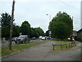
3
The verge of the A21 (Farnborough Way)
This is taken at the end of Orchard Road and looks in the direction of Sevenoaks.
Image: © Marathon
Taken: 23 Apr 2014
0.06 miles
6
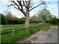
Looking along the A21 (Farnborough Way)
This is taken at the end of Orchard Road and looks in the direction of Sevenoaks.
Image: © Marathon
Taken: 23 Apr 2014
0.07 miles
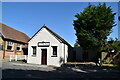
7
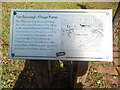
Information Notice by Farnborough Village Pump
This notice is adjacent to the village pump in the High Street and has the following wording and plan:
Farnborough Village Pump
This 1896 map of Farnborough Village
shows the original location of the village
pump opposite Pleasant View. The
original pump was removed around the
turn of the century. This present pump
was obtained by the Farnborough
Village Society at a local auction. After
renovation in 1988 the pump was placed
on the site of the former village pond.
On the right of the notice is the 1896 map of Farnborough village.
Image: © David Hillas
Taken: 23 Sep 2023
0.07 miles
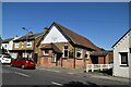
8
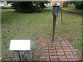
The Village Pump, Farnborough
This village pump is situated in the High Street on the site of the former village pond. The information notice about the pump on the left of the photo is at https://www.geograph.org.uk/photo/7641644.
Image: © David Hillas
Taken: 23 Sep 2023
0.07 miles
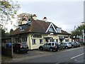
9
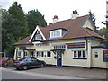
The Woodman, Farnborough
A Shepherd Neame pub on High Street.
Image: © Oast House Archive
Taken: 30 Jul 2015
0.08 miles