IMAGES TAKEN NEAR TO
Homefield Rise, ORPINGTON, BR6 0RW
Introduction
This page details the photographs taken nearby to Homefield Rise, BR6 0RW by members of the Geograph project.
The Geograph project started in 2005 with the aim of publishing, organising and preserving representative images for every square kilometre of Great Britain, Ireland and the Isle of Man.

There are currently over 7.5m images from over14,400 individuals and you can help contribute to the project by visiting https://www.geograph.org.uk
Image Map
Images are licensed for reuse under creativecommons.org/licenses/by-sa/2.0
Notes
- Clicking on the map will re-center to the selected point.
- The higher the marker number, the further away the image location is from the centre of the postcode.
Image Listing (196 Images Found)
Images are licensed for reuse under creativecommons.org/licenses/by-sa/2.0
Image
Details
Distance
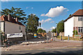
1
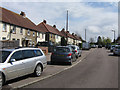
Homefield Rise
Part of a small high density pre-war estate above Orpington High Street.
Image: © Ian Capper
Taken: 24 Apr 2008
0.03 miles
2
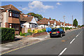
Lancing Road
One of the number of roads in this part of Orpington named after public schools.
Image: © Ian Capper
Taken: 15 Jul 2010
0.04 miles
3
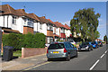
Lancing Road
One of the number of roads in this part of Orpington named after public schools.
Image: © Ian Capper
Taken: 15 Jul 2010
0.08 miles
4
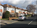
Lancing Road
One of the "public schools" roads in this part of Orpington. Note the standard prewar design of housing.
Image: © Ian Capper
Taken: 6 Feb 2008
0.08 miles
5
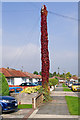
Rampant Virginia Creeper!
A telephone pole taken over by a rampant Virginia Creeper! In Bedford Road, one of the "public schools" roads in this part of Orpington.
The same pole, in a more normal guise, can be seen on the left in Image
Image: © Ian Capper
Taken: 8 Oct 2010
0.08 miles
6
Bedford Road
One of the "public schools" roads in this part of Orpington. The housing in this road is mainly bungalows.
Image: © Ian Capper
Taken: 6 Feb 2008
0.09 miles
7
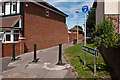
Mortimer Road
Mortimer Road was built in the 1970s or so to connect Lancing Road and Homefield Rise, replacing a house at this point in Lancing Road. At some point later it was blocked off (see Image), presumably because it was being used as a rat run to bypass the High Street. In 2010, it turned full circle, with a house built on the site (seen on the left of this photo).
Despite its status at the Lancing Road end only as a footpath, it still retains its street sign, as seen here.
Image: © Ian Capper
Taken: 17 Aug 2012
0.09 miles
8
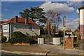
Mortimer Road
Mortimer Road was built in the 1970s or so to connect Lancing Road and Homefield Rise, replacing a house at this point in Lancing Road. At some point later it was blocked off, presumably because it was being used as a rat run to bypass the High Street. In 2010, it turned full circle, with a house built on the site (see Image, Image, Image and Image).
Image: © Ian Capper
Taken: 1 Mar 2010
0.10 miles
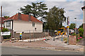
9
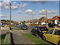
Mortimer Road
Mortimer Road was built in the 1970s or so to connect Lancing Road and Homefield Rise, replacing a house at this point in Lancing Road. At some point later it was blocked off (see Image), presumably because it was being used as a rat run to bypass the High Street. In 2010, it turned full circle, with a house built on the site (see Image).
Here is the first sign of building.
Image: © Ian Capper
Taken: 15 Jul 2010
0.10 miles
10
Mortimer Road
Mortimer Road was built in the 1970s or so to connect Lancing Road and Homefield Rise, replacing a house at this point in Lancing Road. At some point later it was blocked off (see Image), presumably because it was being used as a rat run to bypass the High Street. In 2010, it turned full circle, with a house built on the site.
Here is the early preparation of the site.
Image: © Ian Capper
Taken: 16 Jul 2010
0.10 miles