IMAGES TAKEN NEAR TO
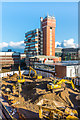
Homefield Rise, ORPINGTON, BR6 0RT
Introduction
This page details the photographs taken nearby to Homefield Rise, BR6 0RT by members of the Geograph project.
The Geograph project started in 2005 with the aim of publishing, organising and preserving representative images for every square kilometre of Great Britain, Ireland and the Isle of Man.

There are currently over 7.5m images from over14,400 individuals and you can help contribute to the project by visiting https://www.geograph.org.uk
Image Map (Loading...)


Getting Data...Please wait
Leaflet Map data © OpenStreetMap
Images are licensed for reuse under creativecommons.org/licenses/by-sa/2.0
Notes
- Clicking on the map will re-center to the selected point.
- The higher the marker number, the further away the image location is from the centre of the postcode.
Image Listing (446 Images Found)
Images are licensed for reuse under creativecommons.org/licenses/by-sa/2.0
Image
Details
Distance
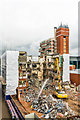
1
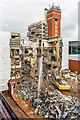
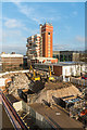
Demolition of former Orpington police station
The former Orpington police station being demolished, in readiness for a housing development to be named Brunswick Square. In the background is the former Orpington College, now the Orpington Campus of Bromley College.
Image: © Ian Capper
Taken: 4 Nov 2015
0.00 miles
2
Demolition of former Orpington police station
The former Orpington police station being demolished, in readiness for a housing development to be named Brunswick Square. In the background is the former Orpington College, now the Orpington Campus of Bromley College.
Image: © Ian Capper
Taken: 4 Nov 2015
0.00 miles
3
Demolition of former Orpington police station
The former Orpington police station being demolished, in readiness for a housing development to be named Brunswick Square. In the background is the former Orpington College, now the Orpington Campus of Bromley College.
Image: © Ian Capper
Taken: 4 Nov 2015
0.00 miles
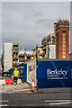
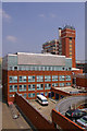
4
Former Orpington Police Station
The former Orpington Police Station prior to its demolition for redevelopment as flats, with hoardings erected alongside the line of Sainsbury's supermarket trolleys in the foreground.
Image: © Ian Capper
Taken: 7 Aug 2015
0.00 miles
5
Demolition of former Orpington police station
The former Orpington police station being demolished, in readiness for a housing development to be named Brunswick Square. In the background is the former Orpington College, now the Orpington Campus of Bromley College.
Image: © Ian Capper
Taken: 4 Nov 2015
0.00 miles
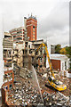
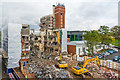
6
Demolition of former Orpington police station
The former Orpington police station being demolished, in readiness for a housing development to be named Brunswick Square. In the left background is the Sainsbury's multi-storey car park.
Image: © Ian Capper
Taken: 4 Nov 2015
0.00 miles
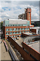
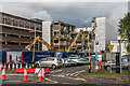
7
Orpington Police Station and Orpington College
Viewed from the Sainsbury's Car park. The Police Station was built in 1984, the College in 1972.
Image: © Ian Capper
Taken: 2 Jul 2009
0.00 miles
8
Demolition of former Orpington police station
The former Orpington police station being demolished, in readiness for a housing development to be named Brunswick Square. In the background is the former Orpington College, now the Orpington Campus of Bromley College.
Image: © Ian Capper
Taken: 4 Nov 2015
0.01 miles
9
Demolition of former Orpington police station
The former Orpington police station being demolished, in readiness for a housing development to be named Brunswick Square. In the background is the former Orpington College, now the Orpington Campus of Bromley College.
Image: © Ian Capper
Taken: 29 Dec 2015
0.01 miles
10
Demolition of former Orpington police station
The former Orpington police station being demolished, in readiness for a housing development to be named Brunswick Square. In the background is the former Orpington College, now the Orpington Campus of Bromley College.
Image: © Ian Capper
Taken: 7 Dec 2015
0.01 miles