IMAGES TAKEN NEAR TO
High Street, ORPINGTON, BR6 0PF
Introduction
This page details the photographs taken nearby to High Street, BR6 0PF by members of the Geograph project.
The Geograph project started in 2005 with the aim of publishing, organising and preserving representative images for every square kilometre of Great Britain, Ireland and the Isle of Man.

There are currently over 7.5m images from over14,400 individuals and you can help contribute to the project by visiting https://www.geograph.org.uk
Image Map
Images are licensed for reuse under creativecommons.org/licenses/by-sa/2.0
Notes
- Clicking on the map will re-center to the selected point.
- The higher the marker number, the further away the image location is from the centre of the postcode.
Image Listing (456 Images Found)
Images are licensed for reuse under creativecommons.org/licenses/by-sa/2.0
Image
Details
Distance
4

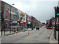
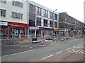
195-215 High Street
Much of the eastern side of High Street was redeveloped in the 1970s or so, and this is one of the blocks from this era.
Image: © Ian Capper
Taken: 22 Nov 2012
0.01 miles
5
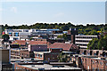
Orpington rooftops
The rooftops of central Orpington as seen from the Walnuts carpark. Running from bottom right to centre left is the line of the High Street, with Tescos prominent in the background.
Image: © Ian Capper
Taken: 5 Sep 2012
0.01 miles
6
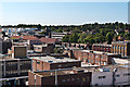
Orpington rooftops
The rooftops of central Orpington as seen from the Walnuts carpark. Running from below centre right to above centre left is the line of the High Street, with the Post Office on the far right of the photo. In the left foreground is part of Walnuts Square.
Image: © Ian Capper
Taken: 5 Sep 2012
0.01 miles
7
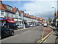
187-197 High Street
Much of the eastern side of High Street was redeveloped in the 1970s or so, and this is one of the blocks from this era.
Image: © Ian Capper
Taken: 4 Mar 2013
0.01 miles
9
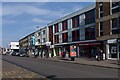
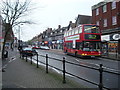
187-215 High Street
Much of the eastern side of High Street was redeveloped in the 1970s or so, and these are some of the blocks from this era.
Image: © Ian Capper
Taken: 4 Mar 2013
0.02 miles
10
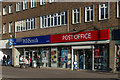
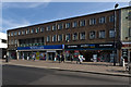
W H Smith and Post Office
The Orpington Branch of W H Smith with new signage reflecting the relocation of Orpington Post Office in a section of the store on 16 February 2017, the day this photo was taken. The old Post Office had closed the previous day, and all branding had already been removed by the following day - see Image
For photo of W H Smith before the rebranding, see Image Note also the filling in of the balcony above the shop front.
Image: © Ian Capper
Taken: 16 Feb 2017
0.02 miles