IMAGES TAKEN NEAR TO
High Street, ORPINGTON, BR6 0ND
Introduction
This page details the photographs taken nearby to High Street, BR6 0ND by members of the Geograph project.
The Geograph project started in 2005 with the aim of publishing, organising and preserving representative images for every square kilometre of Great Britain, Ireland and the Isle of Man.

There are currently over 7.5m images from over14,400 individuals and you can help contribute to the project by visiting https://www.geograph.org.uk
Image Map (Loading...)


Getting Data...Please wait
Leaflet Map data © OpenStreetMap
Images are licensed for reuse under creativecommons.org/licenses/by-sa/2.0
Notes
- Clicking on the map will re-center to the selected point.
- The higher the marker number, the further away the image location is from the centre of the postcode.
Image Listing (418 Images Found)
Images are licensed for reuse under creativecommons.org/licenses/by-sa/2.0
Image
Details
Distance
1

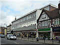
282 High Street
Estate Agency in Orpington High Street, part of a parade built in 1938 on the site of some former oast houses built in the 1860s and in use until 1924, after which the building was converted and used as offices by "The Kentish Times" for a time. Following subsequent demolition of the building in 1938, two of the foundation stones were incorporated in the wall seen here, part of a parade of shops built in its place as part of the ongoing development of Orpington High Street. For a close up of the stones, see Image and Image
Image: © Ian Capper
Taken: 7 Aug 2015
0.00 miles
2
Foundation stone - 282 High Street
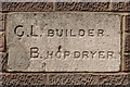
One of a pair of foundation stones incorporated in the wall of 282 High Street (see Image). They were originally from some oast houses that were built on this site in the 1860s and in use until 1924, after which the building was converted and used as offices by "The Kentish Times" for a time. In 1938 the building was demolished and replaced by a parade of shops of which this is a part.
The initials on this stone were of the builder of the oast houses, George Laslett, and a hopdrier, Charles Bristow. For the other foundation stone, see Image Two other foundation stones were also originally in the oast houses but have been lost.
Image: © Ian Capper
Taken: 7 Aug 2015
0.00 miles
3
Foundation stone - 282 High Street
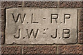
One of a pair of foundation stones incorporated in the wall of 282 High Street (see Image). They were originally from some oast houses that were built on this site in the 1860s and in use until 1924, after which the building was converted and used as offices by "The Kentish Times" for a time. In 1938 the building was demolished and replaced by a parade of shops of which this is a part.
The initials on this stone were of the two workers on the Mayfield estate (of which the oast houses were part), William Laslett and R. Pettit, and of James Wink, local churchwarden, and J. Bond, master plumber. For the other foundation stone, see Image Two other foundation stones were also originally in the oast houses but have been lost.
Image: © Ian Capper
Taken: 7 Aug 2015
0.00 miles
4
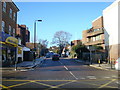
Orpington High Street improvement
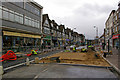
Work underway the Orpington High Street Improvement scheme (see below).
Although initial work was on the pavements, late March/early April saw the southern end of the High Street closed to traffic for work on the roadway itself. Here is one of the raised areas at the site of a light controlled crossing.
Image: © Ian Capper
Taken: 31 Mar 2010
0.01 miles
5
High Street
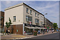
A later addition to the parades that line most of the west side of High Street, situated at the junction with Knoll Rise.
Image: © Ian Capper
Taken: 23 Jun 2010
0.01 miles
6
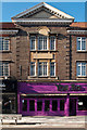
Bancroft House
This 1960s building originally housed the Orpington branch of Tescos. When this closed, the ground floor was split into two, and is now a clothing store in one section and a large furniture retailer in the other. The offices on the second and third floors housed a major benefits consultancy before being vacated in December 2008.
For a photo of the site prior to this development, see http://www.ideal-homes.org.uk/bromley/assets/galleries/orpington/253-high-street - the buildings beyond the cottage are still visible in the current photo.
Image: © Ian Capper
Taken: 23 Oct 2008
0.02 miles
7
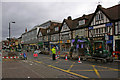
Detail of shopping parade
Detail of one of the shopping parades on Orpington High Street (see Image). For detail of another section of the same parade, see Image
Image: © Ian Capper
Taken: 3 Feb 2012
0.02 miles
9
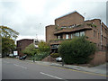
Midas House
One of a group of offices built in the 1980s(?) at the bottom of Knoll Rise near where it joins the High Street. This is not the first block on the site - a 1971 picture at http://www.wsn.co.uk/orpington/history/orp71d.htm shows a different building on the same site, but with housing where other offices on that side of Knoll Rise (for example Berwick House, visible beyond in the current photo) now stand.
Image: © Ian Capper
Taken: 23 Oct 2008
0.02 miles
10
Orpington High Street improvement
Work underway the Orpington High Street Improvement scheme (see below).
Although initial work was on the pavements, late March/early April saw the southern end of the High Street closed to traffic for work on the roadway itself. This is the closure at the junction with Knoll Rise (on the left).
Image: © Ian Capper
Taken: 31 Mar 2010
0.02 miles