IMAGES TAKEN NEAR TO
Paddocks Close, ORPINGTON, BR5 4PP
Introduction
This page details the photographs taken nearby to Paddocks Close, BR5 4PP by members of the Geograph project.
The Geograph project started in 2005 with the aim of publishing, organising and preserving representative images for every square kilometre of Great Britain, Ireland and the Isle of Man.

There are currently over 7.5m images from over14,400 individuals and you can help contribute to the project by visiting https://www.geograph.org.uk
Image Map
Images are licensed for reuse under creativecommons.org/licenses/by-sa/2.0
Notes
- Clicking on the map will re-center to the selected point.
- The higher the marker number, the further away the image location is from the centre of the postcode.
Image Listing (63 Images Found)
Images are licensed for reuse under creativecommons.org/licenses/by-sa/2.0
Image
Details
Distance
2
Eldred Drive
A recent development off Eldred Drive.
Image: © Ian Capper
Taken: 16 May 2012
0.05 miles
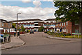
3
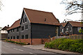
Alma Barn Mews
Barn conversion and associated development completed in 2011 alongside Chelsfield Lane. In the left background is Alma, originally the farmhouse for Tripes Farm (see Image for closer view).
Image: © Ian Capper
Taken: 16 May 2012
0.05 miles
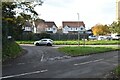
4
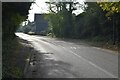
Road junction on Chelsfield Lane
Chelsfield Lane leads from Chelsfield into Orpington.
Skeet Hill Lane leads right towards Well Hill.
Image: © David Anstiss
Taken: 24 Jul 2011
0.06 miles
5
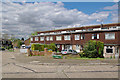
Hardres Terrace
A 1970s terrace on Mosyer Drive, near its junction with Eldred Drive.
Image: © Ian Capper
Taken: 16 May 2012
0.06 miles
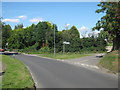
7
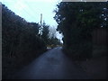
Skeet Hill Lane, Ramsden
This is a genuine country lane but still in the London borough of Bromley
Image: © David Howard
Taken: 12 Feb 2012
0.06 miles
9
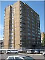
Shelbourne Towers, Orpington
One of two large tower blocks on Chelsfield Road.
Image: © David Anstiss
Taken: 24 Jul 2011
0.06 miles
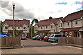
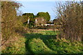
10
Lamberhurst Close
A cul de sac of 1980s housing off Eldred Drive. In the background is one of the blocks typical of the 1960s development of the Ramsden Estate, Peckham House.
Image: © Ian Capper
Taken: 16 May 2012
0.07 miles