IMAGES TAKEN NEAR TO
Somerden Road, ORPINGTON, BR5 4HS
Introduction
This page details the photographs taken nearby to Somerden Road, BR5 4HS by members of the Geograph project.
The Geograph project started in 2005 with the aim of publishing, organising and preserving representative images for every square kilometre of Great Britain, Ireland and the Isle of Man.

There are currently over 7.5m images from over14,400 individuals and you can help contribute to the project by visiting https://www.geograph.org.uk
Image Map
Images are licensed for reuse under creativecommons.org/licenses/by-sa/2.0
Notes
- Clicking on the map will re-center to the selected point.
- The higher the marker number, the further away the image location is from the centre of the postcode.
Image Listing (17 Images Found)
Images are licensed for reuse under creativecommons.org/licenses/by-sa/2.0
Image
Details
Distance
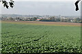
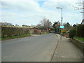
2
View across Derry Downs to St Mary Cray
Image: © Stacey Harris
Taken: 30 Mar 2009
0.11 miles

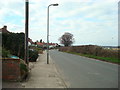
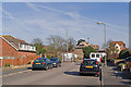
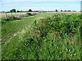
6
On Derry Downs, St Mary Cray
Derry Downs is an informal open space, just east of St Mary Cray. This view looks towards the houses of Cockmannings Road.
Image: © Marathon
Taken: 1 Jul 2011
0.17 miles
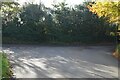
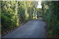
7
Somerden Road
Somerden Road originally ended in this short stub east of Waldenhurst Road. It is now being extended with the houses seen in the background under construction.
Image: © Ian Capper
Taken: 24 Mar 2011
0.18 miles
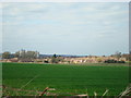
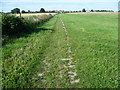
8
Footpath on Derry Downs
Derry Downs is an informal open space, just east of St Mary Cray. This view looks towards the houses of Cockmannings Road.
Image: © Marathon
Taken: 1 Jul 2011
0.20 miles