IMAGES TAKEN NEAR TO
Brantwood Way, ORPINGTON, BR5 3WA
Introduction
This page details the photographs taken nearby to Brantwood Way, BR5 3WA by members of the Geograph project.
The Geograph project started in 2005 with the aim of publishing, organising and preserving representative images for every square kilometre of Great Britain, Ireland and the Isle of Man.

There are currently over 7.5m images from over14,400 individuals and you can help contribute to the project by visiting https://www.geograph.org.uk
Image Map
Images are licensed for reuse under creativecommons.org/licenses/by-sa/2.0
Notes
- Clicking on the map will re-center to the selected point.
- The higher the marker number, the further away the image location is from the centre of the postcode.
Image Listing (61 Images Found)
Images are licensed for reuse under creativecommons.org/licenses/by-sa/2.0
Image
Details
Distance
1
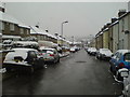
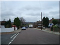
Hearns Road
The houses on the right date from about 1890, those on the left from about 1960.
Image: © Lindsey Coates
Taken: 6 Apr 2008
0.10 miles
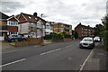
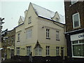
4
The Blue Anchor
The Blue Anchor pub closed in 1996 and was converted to flats in 1997-8, one of 3 pubs in the village to go this way.
Image: © Lindsey Coates
Taken: 6 Apr 2008
0.12 miles
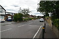
5
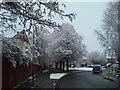
April snow at St Paul's Cray School
The avenue of trees leads to St Paul’s Cray C of E Primary School, which was originally built to be St Mary Cray Secondary School. The school playing field has been reduced by the building of houses, although the remaining field is still usable.
Image: © Lindsey Coates
Taken: 6 Apr 2008
0.13 miles
9
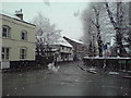
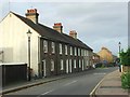
Survey House in April
Survey House is probably the one of the oldest buildings in the village (parts date from around 1500-1520). Damaged by fire, it has been renovated and converted to houses. The Blue Anchor building, at the left of the picture, includes timbers which suggest it was originally built at the same time as Survey House.
Image: © Lindsey Coates
Taken: 6 Apr 2008
0.15 miles
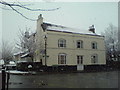
10
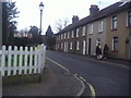
The Old Star
The Old Star pub is another one which has been converted to flats.
Image: © Lindsey Coates
Taken: 6 Apr 2008
0.15 miles