IMAGES TAKEN NEAR TO
Amherst Drive, ORPINGTON, BR5 2ES
Introduction
This page details the photographs taken nearby to Amherst Drive, BR5 2ES by members of the Geograph project.
The Geograph project started in 2005 with the aim of publishing, organising and preserving representative images for every square kilometre of Great Britain, Ireland and the Isle of Man.

There are currently over 7.5m images from over14,400 individuals and you can help contribute to the project by visiting https://www.geograph.org.uk
Image Map
Images are licensed for reuse under creativecommons.org/licenses/by-sa/2.0
Notes
- Clicking on the map will re-center to the selected point.
- The higher the marker number, the further away the image location is from the centre of the postcode.
Image Listing (87 Images Found)
Images are licensed for reuse under creativecommons.org/licenses/by-sa/2.0
Image
Details
Distance
1
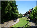
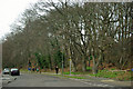
Amherst Wood, St Mary Cray
Seen from Amherst Close, Amherst Wood is a small woodland located between Amherst Drive, Amherst Close and the railway line, just west of St Mary Cray station.
Image: © Marathon
Taken: 27 Jun 2011
0.07 miles
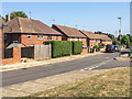
2
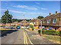
Tillingbourne Green
The eastern side of Tillingbourne Green, with a standard late 1940s design for the immediate area of Threntham Drive and Cray Valley Road as well as here, dating from the late 1940s or early 1950s.
Image: © Ian Capper
Taken: 14 Sep 2016
0.08 miles
3
Five dogs, four humans
On Amherst Drive.
Image: © Robin Webster
Taken: 14 Feb 2012
0.09 miles
4
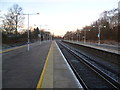
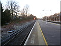
St Mary Cray station on a frosty January morning
In July 1858, the East Kent Railway extended its line from Strood to Bromley. St Mary Cray station was opened on 3rd December 1860 and in 1959 the tracks were increased from two to four. Until the opening of St Pancras International in 2007, Eurostars ran through this station.
This view was taken early on a very frosty Sunday morning in January while waiting for the first train to West Malling. It looks in the direction of Bromley South.
Image: © Marathon
Taken: 12 Jan 2014
0.10 miles
5
St Mary Cray station on a frosty January morning
In July 1858, the East Kent Railway extended its line from Strood to Bromley. St Mary Cray station was opened on 3rd December 1860 and in 1959 the tracks were increased from two to four. Until the opening of St Pancras International in 2007, Eurostars ran through this station.
This view was taken early on a very frosty Sunday morning in January while waiting for the first train to West Malling. It looks in the direction of Bromley South.
Image: © Marathon
Taken: 12 Jan 2014
0.11 miles
6
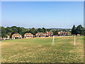
Tillingbourne Green
Looking across to the eastern side of Tillingbourne Green, with a standard housing design for the immediate area of Threntham Drive and Cray Valley Road as well as here, dating from the late 1940s or early 1950s.
Prior to development, old maps show this area, including the open land, to have been woodland.
Image: © Ian Capper
Taken: 14 Sep 2016
0.11 miles
7
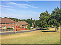
Englefield Crescent
Late 1940s housing at the western end of Tillingbourne Green. Prior to development, old maps show this area, including the open land, to have been woodland.
Image: © Ian Capper
Taken: 14 Sep 2016
0.11 miles
8
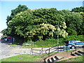
Amherst Wood, St Mary Cray
Seen from the junction of Amherst Close and Amherst Drive, Amherst Wood is a small woodland located between these two roads and the railway line, just west of St Mary Cray station.
Image: © Marathon
Taken: 27 Jun 2011
0.11 miles
10
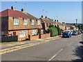
Trentham Drive
A standard design for the immediate area of Threntham Drive, Tillingbourne Green and Cray Valley Road dating from the late 1940s or early 1950s.
Image: © Ian Capper
Taken: 14 Sep 2016
0.12 miles