IMAGES TAKEN NEAR TO
Addington Road, WEST WICKHAM, BR4 9BQ
Introduction
This page details the photographs taken nearby to Addington Road, BR4 9BQ by members of the Geograph project.
The Geograph project started in 2005 with the aim of publishing, organising and preserving representative images for every square kilometre of Great Britain, Ireland and the Isle of Man.

There are currently over 7.5m images from over14,400 individuals and you can help contribute to the project by visiting https://www.geograph.org.uk
Image Map
Images are licensed for reuse under creativecommons.org/licenses/by-sa/2.0
Notes
- Clicking on the map will re-center to the selected point.
- The higher the marker number, the further away the image location is from the centre of the postcode.
Image Listing (58 Images Found)
Images are licensed for reuse under creativecommons.org/licenses/by-sa/2.0
Image
Details
Distance
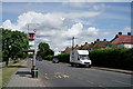
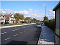
2
Layhams Road Bus Stop
This is in Addington Road. Layhams road is a side street just behind me.
Image: © Des Blenkinsopp
Taken: 1 Jul 2014
0.05 miles
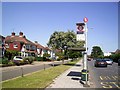
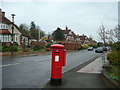
3
West Wickham, Kent: Addington Road
Looking west towards the junction with Glebe Way, (A232).
Image: © Dr Neil Clifton
Taken: 24 Feb 2010
0.05 miles
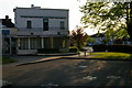
4
West Wickham, Kent: Parkside Dental Surgery
On Addington Road
Image: © Dr Neil Clifton
Taken: 24 Feb 2010
0.06 miles
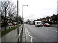
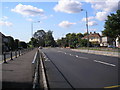
5
Addington Road, West Wickham, Kent
An unremarkable suburban road, part of the A2022. In the distance a bus on Route 353 makes its way from Addington to Orpington.
Image: © Dr Neil Clifton
Taken: 29 Sep 2008
0.06 miles
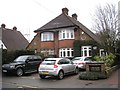
6

Addington Road, Coney Hall
A similar view to Image, taken a little further southwest, with semi-detached houses set back from the A2022 on a service road. The one-way street on the left is Croydon Road.
Image: © Derek Harper
Taken: 9 Dec 2011
0.07 miles
8
Addington Road Health Centre
Inter-war development (serving, inter alia, the large Coney Hall estate built by private developers during the early 1930s): of a similar vintage to Shirley Library a little to the west Image
Image: © Christopher Hilton
Taken: 17 Apr 2011
0.08 miles
9

Addington Road Health Centre
Inter-war development (serving, inter alia, the large Coney Hall estate built by private developers during the early 1930s): of a similar vintage to Shirley Library a little to the west Image
Image: © Christopher Hilton
Taken: 17 Apr 2011
0.08 miles
10
Addington Road, West Wickham, Kent: looking west
This is part of the A2022. In the distance is a roundabout, where a right turn leads up Corkscrew Hill to the centre of West Wickham, and a left turn up Layhams Road leads out into the countryside. Straight on, the A2022 continues as a straight road for about a mile with virtually no junctions: this stretch is known to the local 'lads' as the Mad Mile.
Image: © Dr Neil Clifton
Taken: 29 Sep 2008
0.08 miles