IMAGES TAKEN NEAR TO
Rose Walk, WEST WICKHAM, BR4 0RW
Introduction
This page details the photographs taken nearby to Rose Walk, BR4 0RW by members of the Geograph project.
The Geograph project started in 2005 with the aim of publishing, organising and preserving representative images for every square kilometre of Great Britain, Ireland and the Isle of Man.

There are currently over 7.5m images from over14,400 individuals and you can help contribute to the project by visiting https://www.geograph.org.uk
Image Map
Images are licensed for reuse under creativecommons.org/licenses/by-sa/2.0
Notes
- Clicking on the map will re-center to the selected point.
- The higher the marker number, the further away the image location is from the centre of the postcode.
Image Listing (36 Images Found)
Images are licensed for reuse under creativecommons.org/licenses/by-sa/2.0
Image
Details
Distance
1
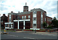
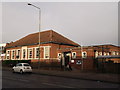
West Wickham Fire Station
West Wickham's fire station opened in July 1939 in Glebe Way, as a sub station of Beckenham Fire Brigade. It was transferred from the Kent A Division to the Greater London Council in 1965, and closed in March 1968. Afterwards it became first a caravan showroom, then a secondhand furniture warehouse.
Image: © Philip Talmage
Taken: 7 Aug 2005
0.09 miles
2
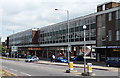
Summit House, West Wickham
On Glebe Way. Built in 1966. A typical 1960s development, with shops at street level and offices above.
Image: © Stephen Richards
Taken: Unknown
0.09 miles
3
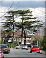
Cedars, Woodland Way
Always a noble sight and surely enough to put a spring in anyone's step.
Specimens such as these in the garden of a normal suburban house suggest the area was built on the grounds of a big house.
Image: © Stephen Richards
Taken: 18 Mar 2012
0.10 miles
6
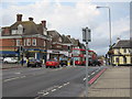
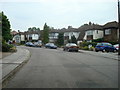
Road Junction, West wickham
Traffic lights at the junction of the A232 Glebe Way where it is crossed by the A214
Image: © Richard Rogerson
Taken: 2 Aug 2013
0.16 miles
7
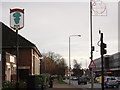
West Wickham Village Sign
On Glebe Way, in front of West Wickham Library.
Image: © David Anstiss
Taken: 18 Dec 2011
0.17 miles
8
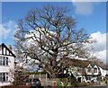
Oak, Woodland Way
A gnarled and venerable specimen (Image]).
It has been encroached upon by suburbia. One hopes the health and safety zealots don't get their hands on it.
Image: © Stephen Richards
Taken: 18 Mar 2012
0.17 miles
9
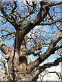
Detail of oak, Woodland Way
It's been in the wars.
Full view here: Image
Image: © Stephen Richards
Taken: 18 Mar 2012
0.17 miles
10
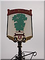
West Wickham Village Sign (close-up)
A close-up of the sign seen in Image
Below the tree, is Invicta - the prancing horse symbol of Kent.
West Wickham until the 1960's was part of the County of Kent, but has now been absorbed into the London Borough of Bromley.
Image: © David Anstiss
Taken: 18 Dec 2011
0.18 miles