IMAGES TAKEN NEAR TO
Brockman Rise, BROMLEY, BR1 5RE
Introduction
This page details the photographs taken nearby to Brockman Rise, BR1 5RE by members of the Geograph project.
The Geograph project started in 2005 with the aim of publishing, organising and preserving representative images for every square kilometre of Great Britain, Ireland and the Isle of Man.

There are currently over 7.5m images from over14,400 individuals and you can help contribute to the project by visiting https://www.geograph.org.uk
Image Map
Images are licensed for reuse under creativecommons.org/licenses/by-sa/2.0
Notes
- Clicking on the map will re-center to the selected point.
- The higher the marker number, the further away the image location is from the centre of the postcode.
Image Listing (50 Images Found)
Images are licensed for reuse under creativecommons.org/licenses/by-sa/2.0
Image
Details
Distance
8
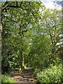
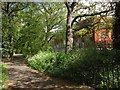
Downham Woodland Walk
The dog waste bin can be seen on the left of Image
Image: © Derek Harper
Taken: 9 May 2013
0.13 miles
9
Downham Woodland Walk
Followed by the Green Chain Walk and the Capital Ring, the walk continues east of Downderry Road. The new building on the right is at what is mapped as an annexe for both Bonus Pastor Catholic College and Catford County School.
Image: © Derek Harper
Taken: 9 May 2013
0.13 miles
10
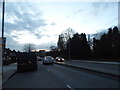
Whitefoot Lane, Southend
The 30 sign is circled by black as it isn't an official sign, they are only used entering a 30 road from another or where there are no street lights. Otherwise the default limit is always 30 unless signed otherwise. These are added by the council, something which has been done for many decades around the country, but in fact the humps make it impossible to even get close to 20 so the signs are pretty superfluous.
Image: © David Howard
Taken: 16 Feb 2014
0.13 miles