IMAGES TAKEN NEAR TO
Downderry Road, BROMLEY, BR1 5QH
Introduction
This page details the photographs taken nearby to Downderry Road, BR1 5QH by members of the Geograph project.
The Geograph project started in 2005 with the aim of publishing, organising and preserving representative images for every square kilometre of Great Britain, Ireland and the Isle of Man.

There are currently over 7.5m images from over14,400 individuals and you can help contribute to the project by visiting https://www.geograph.org.uk
Image Map
Images are licensed for reuse under creativecommons.org/licenses/by-sa/2.0
Notes
- Clicking on the map will re-center to the selected point.
- The higher the marker number, the further away the image location is from the centre of the postcode.
Image Listing (66 Images Found)
Images are licensed for reuse under creativecommons.org/licenses/by-sa/2.0
Image
Details
Distance
1
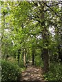
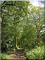
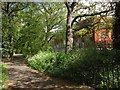
Downham Woodland Walk
Followed by the Green Chain Walk and the Capital Ring, the narrow strip of woodland is here running between housing on Winlaton Road (left) and Downderry Road.
Image: © Derek Harper
Taken: 9 May 2013
0.02 miles
2
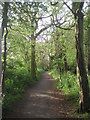
Downham Woodland Walk
The Woodland Walk is a narrow strip of woodland, most of which is considered to be ancient in origin. When the Downham Estate was built by the LCC between 1924 and 1930, the existing woodland strip from Whitefoot Terrace to Bromley Road was retained to become the Woodland Walk, a pleasant green trail through the estate. For the time, this was quite an imaginative move. The Woodland Walk zigzags between the houses of Downham and is now followed by both the Green Chain Walk and the Capital Ring. This view is towards the Bromley Road end of the Walk.
Image: © Marathon
Taken: 11 Apr 2011
0.08 miles
3
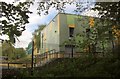
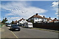
Bonus Pastor Catholic College, Downham
New buildings at the secondary school, seen from Downham Woodland Walk.
Image: © Derek Harper
Taken: 9 May 2013
0.10 miles
8
Downham Woodland Walk
The dog waste bin can be seen on the left of Image
Image: © Derek Harper
Taken: 9 May 2013
0.12 miles
9
Downham Woodland Walk
Followed by the Green Chain Walk and the Capital Ring, the walk continues east of Downderry Road. The new building on the right is at what is mapped as an annexe for both Bonus Pastor Catholic College and Catford County School.
Image: © Derek Harper
Taken: 9 May 2013
0.12 miles
10
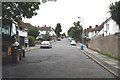
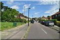
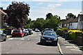
Downham: Haddington Road
Looking north, from where the Green Chain Walk crosses Haddington Road
Image: © Dr Neil Clifton
Taken: 30 Aug 2012
0.12 miles