IMAGES TAKEN NEAR TO
Capstone Road, BROMLEY, BR1 5NB
Introduction
This page details the photographs taken nearby to Capstone Road, BR1 5NB by members of the Geograph project.
The Geograph project started in 2005 with the aim of publishing, organising and preserving representative images for every square kilometre of Great Britain, Ireland and the Isle of Man.

There are currently over 7.5m images from over14,400 individuals and you can help contribute to the project by visiting https://www.geograph.org.uk
Image Map
Images are licensed for reuse under creativecommons.org/licenses/by-sa/2.0
Notes
- Clicking on the map will re-center to the selected point.
- The higher the marker number, the further away the image location is from the centre of the postcode.
Image Listing (32 Images Found)
Images are licensed for reuse under creativecommons.org/licenses/by-sa/2.0
Image
Details
Distance
1
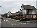
Gittens Close
This small development in an anachronism in two ways. The "mock tudor" half-timbering is obviously out of character with all the other housing in the area, and the houses look relatively new (1980s perhaps) whereas most of the housing in the whole area between Catford and Bromley was developed between the two world wars.
Image: © Stephen Craven
Taken: 26 Aug 2010
0.11 miles
2
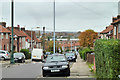
Durham Hill
A suburb outside the London postal zones, in BR1.
Image: © Robin Webster
Taken: 30 Oct 2011
0.12 miles
3
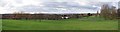
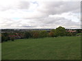
Downham Fields
A large open space in Downham, the Crystal Palace TV transmitter can just be seen on the horizon.
Image: © Glyn Baker
Taken: 1 Feb 2018
0.12 miles
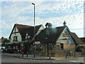
5

Downham Tavern, Downham
At the junction of Downham Way (in front) and Capstone Road (behind the pub).
Not much change since Image (in 2005).
Image: © David Anstiss
Taken: 18 Sep 2011
0.13 miles
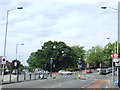
6

Downham Way passes the shops
The bus is on route 136 bound for Peckham.
Image: © Robin Webster
Taken: 30 Oct 2011
0.14 miles
7
View from Downham Fields
Looking towards Crystal Palace TV Tower.
On the right is construction crane near New Woodlands School.
Image: © David Anstiss
Taken: 18 Sep 2011
0.14 miles
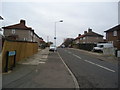
9
Downham Way/Northover junction
The junction of Downham Way and Northover, near Grove Park in South East London.
This area was developed in the 1920s by the London County Council, as part of the Downham Estate. The estate was built to ease a serious housing shortage which existed at the time.
Image: © Malc McDonald
Taken: 25 May 2011
0.15 miles
10

Downham Fields Panorama
Looking across the Sydenham and West Norwood region of London.
Crystal Palace tower can be seen in the middle.
Image: © David Anstiss
Taken: 18 Sep 2011
0.15 miles