IMAGES TAKEN NEAR TO
Madeira Avenue, BROMLEY, BR1 4AZ
Introduction
This page details the photographs taken nearby to Madeira Avenue, BR1 4AZ by members of the Geograph project.
The Geograph project started in 2005 with the aim of publishing, organising and preserving representative images for every square kilometre of Great Britain, Ireland and the Isle of Man.

There are currently over 7.5m images from over14,400 individuals and you can help contribute to the project by visiting https://www.geograph.org.uk
Image Map
Images are licensed for reuse under creativecommons.org/licenses/by-sa/2.0
Notes
- Clicking on the map will re-center to the selected point.
- The higher the marker number, the further away the image location is from the centre of the postcode.
Image Listing (47 Images Found)
Images are licensed for reuse under creativecommons.org/licenses/by-sa/2.0
Image
Details
Distance
1

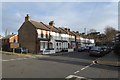
Flats on Madeira Avenue, Bromley
A block of flats near Bromley.
Image: © Malc McDonald
Taken: 25 May 2011
0.06 miles
2

Christ Church, Highland Road, Bromley BR2
Christ Church was built in 1887 in the Early English style by Samuel Cawston, developer of the Bromley Hill estate. Disapproving of travel on Sundays, a church on his new estate saved the journey to the parish church in the centre of town. Originally a chapel of ease to the parish church and later owned by St Mary's, Plaistow, it only became a parish church in its own right in 1923.
Image: © Philip Talmage
Taken: 25 Aug 2005
0.10 miles
3
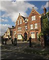
Building on Grasmere Road, Bromley
The striking Harcourt House "was built as a family home in about 1870 by local architect W.A. Williams" http://www.fredasgarden.co.uk/harcourthouse.html . In the war it was used by the Red Cross.
Image: © Derek Harper
Taken: 9 May 2013
0.12 miles
4
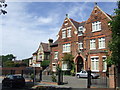
Harcourt House, Bromley
Harcourt House was built in Victorian times as a family home. Between 1908 and 1940, however, it was used as a school before becoming offices for the Red Cross during the Second World War.
The house's garden is occasionally opened to the public. More information can be found on the Freda's Garden website http://www.fredasgarden.co.uk/
Image: © Malc McDonald
Taken: 25 May 2011
0.13 miles
5
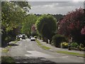
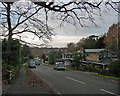
Bromley Avenue, Bromley
You could say, where else? But Elgin lists 7 other Bromley Avenues. This view is looking down the hill towards the Ravensbourne valley from close to the T junction at the top with Grasmere Road.
Image: © Derek Harper
Taken: 9 May 2013
0.15 miles
6

Scotts Avenue BR2
Photograph take where the road descends towards Bromley Road.
Image: © Philip Talmage
Taken: 25 Aug 2005
0.16 miles
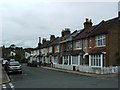
8

Shortlands Gardens
A terraced street in Shortlands near Bromley.
Image: © DS Pugh
Taken: 29 Nov 2014
0.16 miles
9
Bromley Avenue
Leafy inter-war and post-war suburbia.
Image: © Stephen Richards
Taken: 14 Dec 2014
0.17 miles