IMAGES TAKEN NEAR TO
Harbour View Road, NEWHAVEN, BN9 9TT
Introduction
This page details the photographs taken nearby to Harbour View Road, BN9 9TT by members of the Geograph project.
The Geograph project started in 2005 with the aim of publishing, organising and preserving representative images for every square kilometre of Great Britain, Ireland and the Isle of Man.

There are currently over 7.5m images from over14,400 individuals and you can help contribute to the project by visiting https://www.geograph.org.uk
Image Map
Images are licensed for reuse under creativecommons.org/licenses/by-sa/2.0
Notes
- Clicking on the map will re-center to the selected point.
- The higher the marker number, the further away the image location is from the centre of the postcode.
Image Listing (17 Images Found)
Images are licensed for reuse under creativecommons.org/licenses/by-sa/2.0
Image
Details
Distance
2
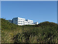
Tideway School
Opened in the mid to late 1960s to cater for both the town of Newhaven and the rapidly expanding town of Peacehaven. Once the latter opened their own school in the early 2000s the school shrank somewhat and much of it was burnt down in 2005 as a result of arson. The new buildings were finally opened in 2008.
Image: © Simon Carey
Taken: 31 Aug 2012
0.06 miles
3
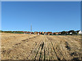
Field, Harbour Heights
This part lies between the inner and outer playing field belonging to Tideway school. Beyond is the new housing development built in the early 2000s.
Image: © Simon Carey
Taken: 31 Aug 2012
0.10 miles
4
Haven Way
Part of a new estate built to the west of Tideway school in the early 00s. It was largely built upon the course of Pevensey Road which had been laid out in the 1920s as part of the Harbour Heights development which only resulted in a few scattered houses being built before 1939, one of which, Bleak House on the right, is now part of the new development.
Image: © Simon Carey
Taken: 31 Aug 2012
0.12 miles
5
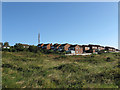
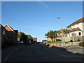
Recent Development, Harbour Heights
Built in the early part of the 00s over the unmade tracks of Pevensey Road, Pegler Avenue and Harbour View Road of which only the latter has survived within the development. Access to the estate is from Southdown Road.
Image: © Simon Carey
Taken: 31 Aug 2012
0.12 miles
6

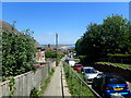
Wilmington Road, Harbour Heights
Laid out in the 1920s and originally linked up to Pevensey Road but since the construction of a small estate to the west of Tideway school it is now a dead end.
Image: © Simon Carey
Taken: 31 Aug 2012
0.13 miles
7
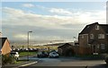
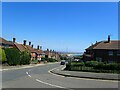
Gibbon Road, Newhaven
This is at the very top of the hill with, as can be seen, a distant view of Seaford Bay.
Image: © Marathon
Taken: 5 Jun 2021
0.15 miles
8
Gibbon Road, Newhaven
This is at the very top of the hill with, as can be seen, a distant view of Seaford Bay.
Image: © Marathon
Taken: 5 Jun 2021
0.15 miles
9
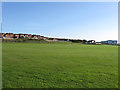
Playing Fields, Tideway School
This is the outer playing field lovely in summer, dreadful in winter with the gales blowing in off the sea. The main school building is to the right.
Image: © Simon Carey
Taken: 31 Aug 2012
0.15 miles
10

Newhaven Transmitter Mast
A BBC digital television and radio relay mast for Heathfield to the north.
Image: © Simon Carey
Taken: 31 Aug 2012
0.16 miles