IMAGES TAKEN NEAR TO
Saxon Road, NEWHAVEN, BN9 9LG
Introduction
This page details the photographs taken nearby to Saxon Road, BN9 9LG by members of the Geograph project.
The Geograph project started in 2005 with the aim of publishing, organising and preserving representative images for every square kilometre of Great Britain, Ireland and the Isle of Man.

There are currently over 7.5m images from over14,400 individuals and you can help contribute to the project by visiting https://www.geograph.org.uk
Image Map
Images are licensed for reuse under creativecommons.org/licenses/by-sa/2.0
Notes
- Clicking on the map will re-center to the selected point.
- The higher the marker number, the further away the image location is from the centre of the postcode.
Image Listing (160 Images Found)
Images are licensed for reuse under creativecommons.org/licenses/by-sa/2.0
Image
Details
Distance
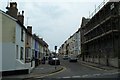
1

Saxon Road
Running between Image and Meeching Rise. The road was laid out and completed in the late 1920s.
Image: © Simon Carey
Taken: 31 Aug 2012
0.00 miles
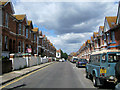
2

Norman Road, Newhaven
The date 1904 is shown on the house to the right which is a good indication on when the rest of the houses in the street were built.
Image: © Kevin Gordon
Taken: 20 Jul 2008
0.03 miles
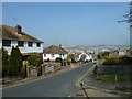
3

Norman Road
Running between Image to the south and South Way to the north. It was laid out in the late 1890s and completed by the turn of the century. The road has a claim to notoriety in that it was the place Lord Lucan's Ford Corsair was discovered on Sunday 8 November 1974 believed to have been left here sometime between 5-8am.
Image: © Simon Carey
Taken: 31 Aug 2012
0.04 miles
4
Meeching Road, Newhaven
Meeching Road, Newhaven.
Image: © Graham Pritchard
Taken: Unknown
0.05 miles
5
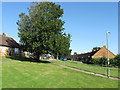
Neill's Close
Viewed from Image and built in the 1970s on the site of a former field and orchard owned by the former Convent of the Sacred Heart that was based in nearby Church Hill.
Image: © Simon Carey
Taken: 31 Aug 2012
0.05 miles
8
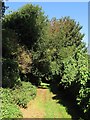
Nun's Walk
Footpath linking Image to Image and a case whereby a local name for a footpath eventually becomes the official one. The footpath skirted lands belonging to the former Convent of the Sacred Heart based in nearby Church Hill.
Image: © Simon Carey
Taken: 31 Aug 2012
0.07 miles
9
Meeching Road, Newhaven
Meeching was the former name for Newhaven which changed its name in the 16th Century after the course of the River Ouse changed to create a new haven here.
Image: © Kevin Gordon
Taken: 20 Jul 2008
0.07 miles
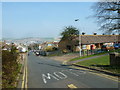
10
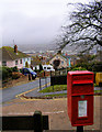
Meeching Rise, Newhaven
Looking down towards the town. The postbox is on the junction of Meeching Rise and Neill's Close.
Image: © Kevin Gordon
Taken: 26 Oct 2008
0.08 miles