IMAGES TAKEN NEAR TO
South Way, NEWHAVEN, BN9 9LA
Introduction
This page details the photographs taken nearby to South Way, BN9 9LA by members of the Geograph project.
The Geograph project started in 2005 with the aim of publishing, organising and preserving representative images for every square kilometre of Great Britain, Ireland and the Isle of Man.

There are currently over 7.5m images from over14,400 individuals and you can help contribute to the project by visiting https://www.geograph.org.uk
Image Map (Loading...)


Getting Data...Please wait
Leaflet Map data © OpenStreetMap
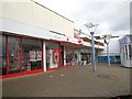
Images are licensed for reuse under creativecommons.org/licenses/by-sa/2.0
Notes
- Clicking on the map will re-center to the selected point.
- The higher the marker number, the further away the image location is from the centre of the postcode.
Image Listing (197 Images Found)
Images are licensed for reuse under creativecommons.org/licenses/by-sa/2.0
Image
Details
Distance
1
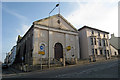
Congregational Chapel, Meeching Road, Newhaven
Built in 1811, and closed in 1938. Used as a Flea Market from the 1970s and now closed for the last few years.
Image: © Oast House Archive
Taken: 22 Mar 2009
0.01 miles
3
Meeching Road, Newhaven
Meeching was the former name for Newhaven which changed its name in the 16th Century after the course of the River Ouse changed to create a new haven here.
Image: © Kevin Gordon
Taken: 20 Jul 2008
0.04 miles
4
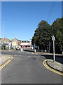
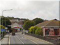
Meeching Road
Meeching is the original name of Newhaven, the latter gradually taking over the name of the settlement from the 16th century onwards. This view takes in the crossing of South Way and looking towards its junction with High Street. Prior to the ring road being built in the 1970s the junction on the left was with Meeching Rise whilst on the right was the junction with Dacre Road in the middle of which stood the Newhaven Transport Memorial which was moved in 1977 to a spot by the river and then onto Image in the 1990s. Beyond the road junction where the trees are was once the site of the town's police station whilst on the left the cleared site was once a large house called Saxonholme which was demolished in 2006 and next door to that on the site of Image was the town's fire station.
Image: © Simon Carey
Taken: 26 Aug 2012
0.04 miles
5
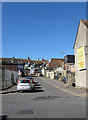
Marshalls Lane
Small cul de sac off Meeching Road that was laid out as an access road for the rear of shops in the High Street during the 1970s. Previously this had been the site of the old fire station which also once a cinema. The houses beyond the wall are on South Way.
Image: © Simon Carey
Taken: 26 Aug 2012
0.04 miles
6
Meeching Road, Newhaven
Meeching Road, Newhaven.
Image: © Graham Pritchard
Taken: Unknown
0.04 miles
7

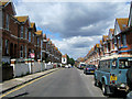
Norman Road, Newhaven
The date 1904 is shown on the house to the right which is a good indication on when the rest of the houses in the street were built.
Image: © Kevin Gordon
Taken: 20 Jul 2008
0.04 miles
8

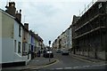
Norman Road
Running between Image to the south and South Way to the north. It was laid out in the late 1890s and completed by the turn of the century. The road has a claim to notoriety in that it was the place Lord Lucan's Ford Corsair was discovered on Sunday 8 November 1974 believed to have been left here sometime between 5-8am.
Image: © Simon Carey
Taken: 31 Aug 2012
0.05 miles
9

Market Stall, Newhaven High Street
The market was opened in October 2013, funded with money secured from the Mary Portas scheme to revive flagging high streets. http://www.sussexexpress.co.uk/news/local/new-market-pulls-in-the-crowds-to-newhaven-high-street-1-5378858
Image: © Paul Gillett
Taken: 9 Jan 2014
0.05 miles