IMAGES TAKEN NEAR TO
Lewes Road, NEWHAVEN, BN9 9AG
Introduction
This page details the photographs taken nearby to Lewes Road, BN9 9AG by members of the Geograph project.
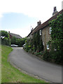
The Geograph project started in 2005 with the aim of publishing, organising and preserving representative images for every square kilometre of Great Britain, Ireland and the Isle of Man.

There are currently over 7.5m images from over14,400 individuals and you can help contribute to the project by visiting https://www.geograph.org.uk
Image Map
Images are licensed for reuse under creativecommons.org/licenses/by-sa/2.0
Notes
- Clicking on the map will re-center to the selected point.
- The higher the marker number, the further away the image location is from the centre of the postcode.
Image Listing (135 Images Found)
Images are licensed for reuse under creativecommons.org/licenses/by-sa/2.0
Image
Details
Distance
1
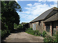
Flint Barns, Courthouse Farm
The adjacent track is also the footpath to Peacehaven Heights.
Image: © Simon Carey
Taken: 9 Jun 2012
0.03 miles
2
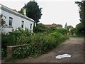
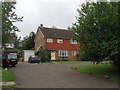
Courthouse Farm
Parts of the building date from the 16th century but the house has been much altered over the years. It is inhabited though the small front garden could do with tidying up as it is getting a little bit overgrown. Once the major farm of the village.
Image: © Simon Carey
Taken: 16 Jun 2012
0.05 miles
3
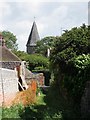
Old Lane
The former lane to Courthouse Farm was severed when Piddinghoe's by-pass was completed in 1923 and is now little more than a footpath. The tower of St John's church can also be seen.
Image: © Simon Carey
Taken: 9 Jun 2012
0.07 miles
4
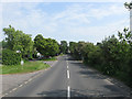
Lewes Road
Currently the C7 but until the 1970s it was the A275 until the by-pass at Lewes and the new ring road at Newhaven moved much of the port traffic up the eastern side of the Ouse valley thus avoiding the narrow streets of the former. The junction on the left leads into the village of Piddinghoe itself whilst the route straight ahead is possibly one of the earliest by-passes built for motor vehicle traffic having opened in 1923 to avoid the narrow meandering village street.
Image: © Simon Carey
Taken: 2 Jun 2012
0.07 miles
5
Court Farm Close
Small cul de sac off the main village street built in 1972 on what was the original farmyard of Court House Farm.
Image: © Simon Carey
Taken: 16 Jun 2012
0.07 miles
6
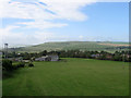
Barns, Courthouse Farm
At the foot of Nore Down with the village of Piddinghoe beyond. Itford and Beddingham Hills provide the backdrop.
Image: © Simon Carey
Taken: 16 Jun 2012
0.08 miles
7
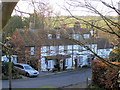
Blythe Cottages, Piddinghoe
This building is now split into four separate cottages named (from left to right) Halyards, Compass Cottage, Creek Cottage and Blythe Cottage. They date from the 18th century and were listed Grade II in September 1979. This photo was taken from the Church yard.
Image: © Kevin Gordon
Taken: 28 Dec 2008
0.08 miles
8
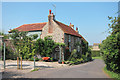
Flint Cottage
Grade II listed http://list.english-heritage.org.uk/resultsingle.aspx?uid=1238103 flint cottages.
Image: © Oast House Archive
Taken: 1 Sep 2011
0.09 miles
9
St John's Cottage
An 18th century cottage on the main village street. Its next door neighbour is Image
Image: © Simon Carey
Taken: 16 Jun 2012
0.09 miles
10
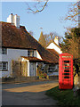
The Old Post Office, Piddinghoe
Although there is a date 'Maye 1620' close to the door of this building it is actually much older and some timbers date from the 15th century. It was once an open-hall house but the chimney was added in 1600. The building was once a pub before it became the village post office. The spire of St John's church with its famous fishy weathervane can be seen behind.
Image: © Kevin Gordon
Taken: 28 Dec 2008
0.09 miles