IMAGES TAKEN NEAR TO
Heighton Crescent, NEWHAVEN, BN9 0QS
Introduction
This page details the photographs taken nearby to Heighton Crescent, BN9 0QS by members of the Geograph project.
The Geograph project started in 2005 with the aim of publishing, organising and preserving representative images for every square kilometre of Great Britain, Ireland and the Isle of Man.

There are currently over 7.5m images from over14,400 individuals and you can help contribute to the project by visiting https://www.geograph.org.uk
Image Map
Images are licensed for reuse under creativecommons.org/licenses/by-sa/2.0
Notes
- Clicking on the map will re-center to the selected point.
- The higher the marker number, the further away the image location is from the centre of the postcode.
Image Listing (62 Images Found)
Images are licensed for reuse under creativecommons.org/licenses/by-sa/2.0
Image
Details
Distance
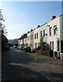
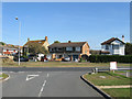
1
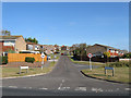
Iveagh Crescent
Viewed from the junction with Avis Road. The road and surrounding estate were built in the 1970s.
Image: © Simon Carey
Taken: 22 Oct 2011
0.06 miles
5
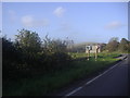
New Road, South Heighton
Overlooking the South Downs
Image: © David Howard
Taken: 12 Sep 2011
0.12 miles
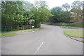
6
Iveagh Crescent
A continuation of Denton Rise that heads back towards the B2109. The estate was built in the 1970s.
Image: © Simon Carey
Taken: 21 Feb 2009
0.12 miles
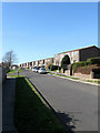
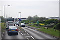
8
New Road
The middle set of cottages were built during the late 1890s and the other set at either end were completed by 1910. Up until the early 1980s this was the northern end of New Road which joined Avis Road at this point, however, it was closed off at the western end and a new wider road built to the rear of the cottages which is now the course of the A26.
Image: © Simon Carey
Taken: 22 Oct 2011
0.13 miles
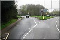
9
138-146 Avis Road
Located in a cut off of the original road which straightened in the 1960s. The houses are of differing ages, number 144-46 on the right is the oldest building dating from the first decade of the 20th century and remained in isolation until the building of 138 in the 1930s. Numbers 140-42 were added during the 1960s. Viewed from one of the entrances to Paradise Park.
Image: © Simon Carey
Taken: 22 Oct 2011
0.13 miles
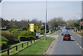
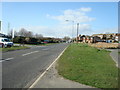
10
Avis Rd outside Paradise Park
A large leisure complex http://www.paradisepark.co.uk/index.html
Image: © N Chadwick
Taken: 29 Apr 2010
0.13 miles