IMAGES TAKEN NEAR TO
The Broyle, LEWES, BN8 6ES
Introduction
This page details the photographs taken nearby to The Broyle, BN8 6ES by members of the Geograph project.
The Geograph project started in 2005 with the aim of publishing, organising and preserving representative images for every square kilometre of Great Britain, Ireland and the Isle of Man.

There are currently over 7.5m images from over14,400 individuals and you can help contribute to the project by visiting https://www.geograph.org.uk
Image Map
Images are licensed for reuse under creativecommons.org/licenses/by-sa/2.0
Notes
- Clicking on the map will re-center to the selected point.
- The higher the marker number, the further away the image location is from the centre of the postcode.
Image Listing (28 Images Found)
Images are licensed for reuse under creativecommons.org/licenses/by-sa/2.0
Image
Details
Distance
1
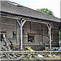
Outbuilding near Bell Farm
This is an unusual structure - slightly more interesting than your average outbuilding.
Image: © Ian Hawfinch
Taken: 15 Jun 2021
0.03 miles
4
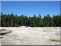
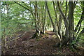
Shortgate Wood
The clearing is to the rear of Marlie Farm. The wood itself is fairly recent having previously been part of Shortgate Common until its enclosure in the early 19th century though it was marked as a wood on the 1838 tithe map.
Image: © Simon Carey
Taken: 3 Jun 2010
0.13 miles
6
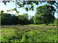
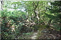
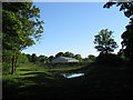
Shortgate Field
The name of the field according to the 1839 tithe map and the eastern most one in Ringmer parish.
Image: © Simon Carey
Taken: 3 Jun 2010
0.14 miles
8
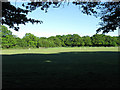
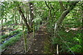
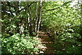
Ox Pasture
The name of the field according to the 1838 tithe map. The bridleway from Shortgate to Laughton Road lies beyond the far end of the field.
Image: © Simon Carey
Taken: 3 Jun 2010
0.16 miles
9
Marlie Farm
Site of Festival Fireworks which exploded in 2006 killing two fireman.
Image: © Simon Carey
Taken: 3 Jun 2010
0.16 miles