IMAGES TAKEN NEAR TO
Southerham Lane, LEWES, BN8 6DY
Introduction
This page details the photographs taken nearby to Southerham Lane, BN8 6DY by members of the Geograph project.
The Geograph project started in 2005 with the aim of publishing, organising and preserving representative images for every square kilometre of Great Britain, Ireland and the Isle of Man.

There are currently over 7.5m images from over14,400 individuals and you can help contribute to the project by visiting https://www.geograph.org.uk
Image Map
Images are licensed for reuse under creativecommons.org/licenses/by-sa/2.0
Notes
- Clicking on the map will re-center to the selected point.
- The higher the marker number, the further away the image location is from the centre of the postcode.
Image Listing (34 Images Found)
Images are licensed for reuse under creativecommons.org/licenses/by-sa/2.0
Image
Details
Distance
1
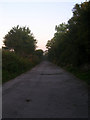
Old Course of A27
Until the mid 1970s this was the main A27. Once the Lewes by-pass and the Cuilfail Tunnel were built the old route through Southerham returned to either quite backwater lanes or were abandoned. For a while it was used as a permitted site for travellers for which bins and taps are still extant, however, the entrance on the A27 has now been completely blocked off.
Image: © Simon Carey
Taken: 20 Sep 2008
0.03 miles
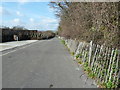
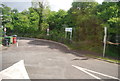
2

Turn off for Bridle Tan
Bridle Tan appears to be a temporary site for caravans.
Image: © Dave Spicer
Taken: 26 Feb 2012
0.03 miles
3
Bridle Tan a semi residential site for caravans
Image: © Dave Spicer
Taken: 26 Feb 2012
0.03 miles
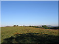
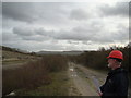
7
View of Old Quarries at Southerham
As viewed from the small hill called Upper Rise.
Image: © Brian Westlake
Taken: 13 Aug 2022
0.05 miles
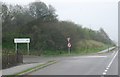
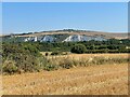
8
Hempshalls
The name of the field according to an 1822 estate map of Southerham Farm that lies between the A27 and the disused Southerham Grey Pit. Another disused chalk quarry, Offham Pit, is visible in the distance on the side of Offham Hill.
Image: © Simon Carey
Taken: 9 Sep 2012
0.06 miles
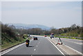
9
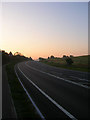
Ranscombe Hill
As well as being the name of a nearby hill it is also used for the road too. Two years of road works between Southerham Roundabout and Beddingham have resulted in a much smoother journey on this section. Taken at dawn hence the lack of traffic.
Image: © Simon Carey
Taken: 20 Sep 2008
0.09 miles
10
View of the South Downs from the Southerham Grey Pit
Looking east, parallel to the railway line, which is down in an embankment beneath the trees to the right.
Image: © Robert Lamb
Taken: 26 Nov 2011
0.15 miles