IMAGES TAKEN NEAR TO
Deans Meadow, LEWES, BN8 5DX
Introduction
This page details the photographs taken nearby to Deans Meadow, BN8 5DX by members of the Geograph project.
The Geograph project started in 2005 with the aim of publishing, organising and preserving representative images for every square kilometre of Great Britain, Ireland and the Isle of Man.

There are currently over 7.5m images from over14,400 individuals and you can help contribute to the project by visiting https://www.geograph.org.uk
Image Map
Images are licensed for reuse under creativecommons.org/licenses/by-sa/2.0
Notes
- Clicking on the map will re-center to the selected point.
- The higher the marker number, the further away the image location is from the centre of the postcode.
Image Listing (56 Images Found)
Images are licensed for reuse under creativecommons.org/licenses/by-sa/2.0
Image
Details
Distance
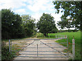
2
Clappers Bridge
Carrying Spithurst Lane over Bevern Stream towards the village of Barcombe Cross.
Image: © Simon Carey
Taken: 6 Jan 2008
0.07 miles
3
Clapper?s Bridge
Clapper’s Bridge near Barcombe Cross.
Image: © Chris Thomas-Atkin
Taken: 15 Oct 2017
0.09 miles
4
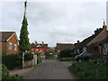
School Field
Small post war cul-de-sac in Barcombe Cross.
Image: © Simon Carey
Taken: 3 Apr 2011
0.09 miles
5
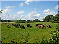
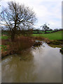
Cattle near Clapper's Bridge
The field is watered by Bevern Stream to the left.
Image: © Robin Webster
Taken: 16 Jun 2012
0.09 miles
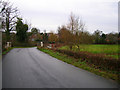
6
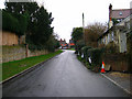
School Hill
Heading northwards out of Barcombe Cross on its way to Spithurst and Newick. Ten World War Two anti-tank cylinders are to the left a remnant of the former military roadblock that was located here during that conflict.
Image: © Simon Carey
Taken: 3 Apr 2011
0.10 miles
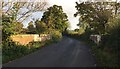
7
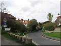
School Hill, Barcombe Cross
Lane from Spithurst and Newick heading up towards the centre of the village. The small dwelling on the right is Covenanters Cottage.
Image: © Simon Carey
Taken: 6 Jan 2008
0.11 miles
8
School Path
Looking towards the junction with Image When the road reaches the school it turns east becoming School Gardens then Image
Image: © Simon Carey
Taken: 3 Apr 2011
0.11 miles
9
Bevern Stream
A tributary of the River Ouse that rises near Ditchling Common. Taken from Clapper Bridge.
Image: © Simon Carey
Taken: 6 Jan 2008
0.12 miles
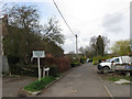
10
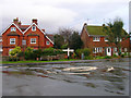
The Square, Barcombe Cross
Point where High Street meets School Hill, carrying the line from Chithurst and Newick from the left, and Barcombe Mills Road taking the lane to its namesake to the right.
Image: © Simon Carey
Taken: 6 Jan 2008
0.12 miles