IMAGES TAKEN NEAR TO
Newhaven Road, LEWES, BN7 3NE
Introduction
This page details the photographs taken nearby to Newhaven Road, BN7 3NE by members of the Geograph project.
The Geograph project started in 2005 with the aim of publishing, organising and preserving representative images for every square kilometre of Great Britain, Ireland and the Isle of Man.

There are currently over 7.5m images from over14,400 individuals and you can help contribute to the project by visiting https://www.geograph.org.uk
Image Map
Images are licensed for reuse under creativecommons.org/licenses/by-sa/2.0
Notes
- Clicking on the map will re-center to the selected point.
- The higher the marker number, the further away the image location is from the centre of the postcode.
Image Listing (62 Images Found)
Images are licensed for reuse under creativecommons.org/licenses/by-sa/2.0
Image
Details
Distance
1
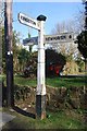
Old Direction Sign - Signpost by Kingston Road, Lewes
Black iron cap finial - 3 arms; East Sussex wood by the UC road, in parish of Kingston near Lewes (Lewes District), Kingston Road, on verge opposite junction of Wellgreen Lane (outside Lewes Garden Centre).
Surveyed
Milestone Society National ID: SX_TQ4008
Image: © Milestone Society
Taken: Unknown
0.02 miles
2
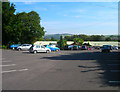
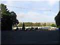
Wyevale Garden Centre, near Kingston
Just off the C7 near to the Kingston turning. A shame it isn't connected to the footpath running past the rear of its premises as it has a small cafe that provides a welcome respite to a few hours walking.
Image: © Simon Carey
Taken: 21 Sep 2008
0.02 miles
3
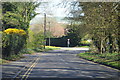
Wellgreen Lane
Approaching junction with Kingston Road.
Image: © J.Hannan-Briggs
Taken: 12 Apr 2015
0.04 miles
4
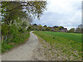
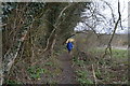
Permissive path, Kingston near Lewes
A link from public footpath Kingston near Lewes 1 into the village itself and also to a path parallel to Kingston Road this side of the far hedge that appears to be set up as a cycleway. Footpath Kingston near Lewes, from and including the Droveway, this link, and the far path are part of the 'Egrets Way' cycleway project.
Image: © Robin Webster
Taken: 29 Apr 2021
0.04 miles
5
Lewes Garden Centre
Originally part of Image it became Swanborough Nurseries after the Second World War. The current garden centre run by Wyevale opened in 1990.
Image: © Simon Carey
Taken: 12 Aug 2012
0.04 miles
6
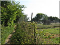
Smallholding next to footpath leading to Kingston Road
Image: © Dave Spicer
Taken: 14 May 2010
0.08 miles
8
Upper Ham
The name of the field according to Kingston's 1843 tithe map that was originally part of a much larger open field that was enclosed in 1834. The smaller field has now been subdivided into even smaller portions some of which have been built upon, the northern section now the location of Lewes Garden Centre.
Image: © Simon Carey
Taken: 26 Jul 2012
0.09 miles
9
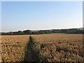
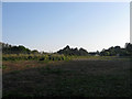
Lower Ham (1)
The name of the field according to Kingston's 1843 tithe map and one of the old open fields that survived in the parish until enclosure in 1834. Other than the northern tip the rest of this field has survived intact. The footpath heads south to Iford. See Image for the opposite view.
Image: © Simon Carey
Taken: 26 Jul 2012
0.09 miles
10
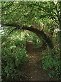
Footpath to Iford
Running past the rear of the Wyevale garden centre. The footpath begins on Kingston Road and runs parallel to the C7 as it heads south to Iford then continues on to Northease.
Image: © Simon Carey
Taken: 12 Aug 2012
0.09 miles