IMAGES TAKEN NEAR TO
Riverdale, Church Lane, LEWES, BN7 2JL
Introduction
This page details the photographs taken nearby to Riverdale, Church Lane, BN7 2JL by members of the Geograph project.
The Geograph project started in 2005 with the aim of publishing, organising and preserving representative images for every square kilometre of Great Britain, Ireland and the Isle of Man.

There are currently over 7.5m images from over14,400 individuals and you can help contribute to the project by visiting https://www.geograph.org.uk
Image Map
Images are licensed for reuse under creativecommons.org/licenses/by-sa/2.0
Notes
- Clicking on the map will re-center to the selected point.
- The higher the marker number, the further away the image location is from the centre of the postcode.
Image Listing (114 Images Found)
Images are licensed for reuse under creativecommons.org/licenses/by-sa/2.0
Image
Details
Distance
1
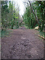
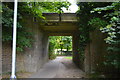
Dismantled Railway, South Malling
Church Lane bridge can be seen in the background. This is the last visible remains of the Uckfield to Lewes line as the everything south of this point has been eradicated.
Image: © Simon Carey
Taken: 12 Apr 2006
0.01 miles
3
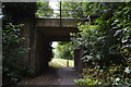
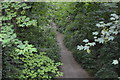
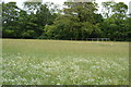
Former Railway Embankment
Once carried the Lewes-Uckfield line that began crossing The Brooks at this point as it headed south to Lewes Station. The line shut in 1969 having originally survived Beeching's axe but not Lewes Town Council's desire to build a bypass that happened to cross railway land. The path from Willeys Bridge to South Malling goes under the bridge to the left.
Image: © Simon Carey
Taken: 29 Apr 2007
0.04 miles
4
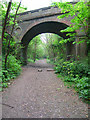
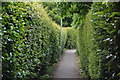
Church Lane Bridge, South Malling
Old railway bridge on the former Lewes-Uckfield line. The track is now a public footpath.
Image: © Simon Carey
Taken: 29 Apr 2007
0.04 miles
6
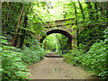
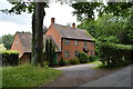
Church Lane bridge
One of two bridges over the cutting once occupied by the Lewes to Uckfield railway line.
Image: © Robin Webster
Taken: 21 May 2014
0.05 miles