IMAGES TAKEN NEAR TO
Houndean Rise, LEWES, BN7 1EJ
Introduction
This page details the photographs taken nearby to Houndean Rise, BN7 1EJ by members of the Geograph project.
The Geograph project started in 2005 with the aim of publishing, organising and preserving representative images for every square kilometre of Great Britain, Ireland and the Isle of Man.

There are currently over 7.5m images from over14,400 individuals and you can help contribute to the project by visiting https://www.geograph.org.uk
Image Map
Images are licensed for reuse under creativecommons.org/licenses/by-sa/2.0
Notes
- Clicking on the map will re-center to the selected point.
- The higher the marker number, the further away the image location is from the centre of the postcode.
Image Listing (11 Images Found)
Images are licensed for reuse under creativecommons.org/licenses/by-sa/2.0
Image
Details
Distance
2
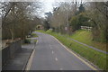
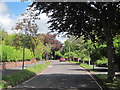
Brighton Road
South West of Lewes Prison
Image: © Paul Gillett
Taken: 2 Jan 2010
0.05 miles
4
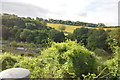
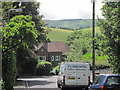
Houndean Area, Lewes
With Offham Hill and Mount Harry in the distance. Taken from Juggs Lane.
Image: © Kevin Gordon
Taken: 31 Jan 2009
0.09 miles
5

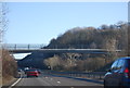
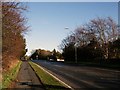
Brighton Road, Lewes
The way into Lewes from Brighton, the former main road before the A27 bypass was built.
Image: © Robin Webster
Taken: 15 May 2010
0.15 miles
6
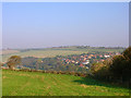
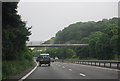
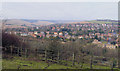
Houndean Bottom, near Lewes
Taken from Juggs Road in the southern end of the square looking north. The dip in between conceals the A27 trunk road and railway. The square itself ends just after the clump of tree to the left.
Image: © Simon Carey
Taken: 16 Oct 2005
0.15 miles