IMAGES TAKEN NEAR TO
Marchants Road, HASSOCKS, BN6 9UT
Introduction
This page details the photographs taken nearby to Marchants Road, BN6 9UT by members of the Geograph project.
The Geograph project started in 2005 with the aim of publishing, organising and preserving representative images for every square kilometre of Great Britain, Ireland and the Isle of Man.

There are currently over 7.5m images from over14,400 individuals and you can help contribute to the project by visiting https://www.geograph.org.uk
Image Map
Images are licensed for reuse under creativecommons.org/licenses/by-sa/2.0
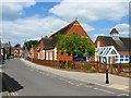
Notes
- Clicking on the map will re-center to the selected point.
- The higher the marker number, the further away the image location is from the centre of the postcode.
Image Listing (219 Images Found)
Images are licensed for reuse under creativecommons.org/licenses/by-sa/2.0
Image
Details
Distance
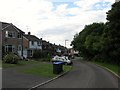
1
St Christopher's Road, Hurstpierpoint
Small cul de sac off Marchants Road built in the late 60s/early 70s. Beyond the fence is the ground of St Lawrence's School.
Image: © Simon Carey
Taken: 6 Jul 2014
0.05 miles
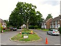
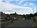
2
Marchants Road, Hurstpierpoint
Looking eastwards from the Cuckfield Road end. The junction with Image is to the left and Image to the right. The road then heads off to a junction with Trinity Road.
Image: © Simon Carey
Taken: 6 Jul 2014
0.05 miles
3
Marchants Close, Hurstpierpoint
Small cup de sac off Marchants Road that is part of an estate built in the late 60s/early 70s. Beyond the trees to the right are ponds belonging to Little Park Farm.
Image: © Simon Carey
Taken: 6 Jul 2014
0.05 miles
4
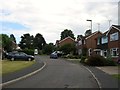
Park Close, Hurstpierpoint
A small cup de sac off Marchants Road. Beyond the fence in the distance is Trinity Road.
Image: © Simon Carey
Taken: 6 Jul 2014
0.08 miles
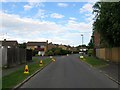
5
Wilderness Road, Hurstpierpoint
A looping road off marchants Road built in the late 1960s/early 1970s. Named after The Wilderness which is the wood beyond the estate.
Image: © Simon Carey
Taken: 6 Jul 2014
0.08 miles
6
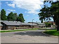
Village Centre and Library, Trinity Road, Hurstpierpoint
Built in the 1980s next to Image
Image: © Simon Carey
Taken: 31 May 2014
0.09 miles
7
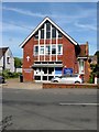
Methodist Church, Cuckfield Road, Hurstpierpoint
Built between the wars.
Image: © Simon Carey
Taken: 17 Jul 2014
0.10 miles
8
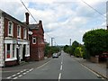
Calico, Cuckfield Road, Hurstpierpoint
The print and web design company has occupied what was once the Sussex Arms, a 19th century brewery tap, since 2006. See Image for part of the old brewery. Cuckfield Road was built as a turnpike in the late 18th century and was one of a number of competing London-Brighton routes before they were all superseded by a route to the west which later became the A23.
Image: © Simon Carey
Taken: 22 Jun 2014
0.11 miles
10
St Lawrence's School, Trinity Road, Hurstpierpoint
Originally opened as a National School in the mid 19th century and now the village primary school.
Image: © Simon Carey
Taken: 31 May 2014
0.13 miles