IMAGES TAKEN NEAR TO
Cuckfield Road, HASSOCKS, BN6 9SG
Introduction
This page details the photographs taken nearby to Cuckfield Road, BN6 9SG by members of the Geograph project.
The Geograph project started in 2005 with the aim of publishing, organising and preserving representative images for every square kilometre of Great Britain, Ireland and the Isle of Man.

There are currently over 7.5m images from over14,400 individuals and you can help contribute to the project by visiting https://www.geograph.org.uk
Image Map
Images are licensed for reuse under creativecommons.org/licenses/by-sa/2.0
Notes
- Clicking on the map will re-center to the selected point.
- The higher the marker number, the further away the image location is from the centre of the postcode.
Image Listing (250 Images Found)
Images are licensed for reuse under creativecommons.org/licenses/by-sa/2.0
Image
Details
Distance
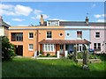
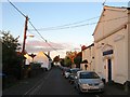
1
Manor Road, Hurstpierpoint
The building on the right is the former Hurst Brewery which opened in 1862 and closed after the First World War after which it became a cheese factory before passing into the hands of the sports company Slazenger. The former site was converted into residential dwellings in 2006.
Image: © Simon Carey
Taken: 22 Jun 2014
0.03 miles
3
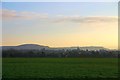
Evening Over Hurstpierpoint
Hurstpierpoint silhouetted against the South Downs.
Image: © Peter Jeffery
Taken: 1 Feb 2007
0.04 miles
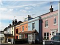
4
29-31 High Street, Hurstpierpoint
The four cottages also include 29a and 31a and date from the mid 19th century.
Image: © Simon Carey
Taken: 31 May 2014
0.04 miles
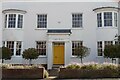
5
Wellesley House, Manor Road, Hurstpierpoint
A former 19th century Wesleyan Chapel that was converted first to a club and more recently business premises. Further down the street are the former brewery premises now converted into residences.
Image: © Simon Carey
Taken: 6 Jul 2014
0.04 miles
6
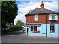
57 High Street, Hurstpierpoint
Home to the UK Cookshop and located on the corner of Cuckfield Road.
Image: © Simon Carey
Taken: 31 May 2014
0.04 miles
8
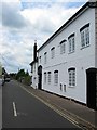
Lamb House, Cuckfield Road, Hurstpierpoint
Dating from the early 19th century and possibly originally part of the neighbouring Lamb Inn, of which only the building with the arch survives, see http://www.closedpubs.co.uk/sussex/hurstpierpoint_lambinn.html for a similar view from the early part of the 20th century. Not sure when the pub closed or when the old building was redeveloped.
Image: © Simon Carey
Taken: 17 Jul 2014
0.05 miles
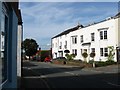
9
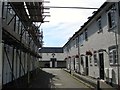
Brewery Mews, Hurstpierpoint
A small cul de sac off Cuckfield Road containing residences converted from the former buildings of Hurst Brewery which opened in 1862 and closed after the First World War after which it became a cheese factory before passing into the hands of the sports company Slazenger. The former site was converted into residential dwellings in 2006.
Image: © Simon Carey
Taken: 17 Jul 2014
0.05 miles
10
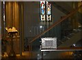
Inside Holy Trinity, Hurstpierpoint (I)
Image: © Basher Eyre
Taken: 3 Nov 2014
0.05 miles