IMAGES TAKEN NEAR TO
Hassocks Road, HASSOCKS, BN6 9QW
Introduction
This page details the photographs taken nearby to Hassocks Road, BN6 9QW by members of the Geograph project.
The Geograph project started in 2005 with the aim of publishing, organising and preserving representative images for every square kilometre of Great Britain, Ireland and the Isle of Man.

There are currently over 7.5m images from over14,400 individuals and you can help contribute to the project by visiting https://www.geograph.org.uk
Image Map
Images are licensed for reuse under creativecommons.org/licenses/by-sa/2.0
Notes
- Clicking on the map will re-center to the selected point.
- The higher the marker number, the further away the image location is from the centre of the postcode.
Image Listing (49 Images Found)
Images are licensed for reuse under creativecommons.org/licenses/by-sa/2.0
Image
Details
Distance
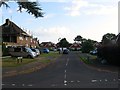
1
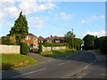
Tott Hill, Hurstpierpoint
The name of the small close on the left off Hassocks Road, the B2116, built in the 1960s in the grounds of an old Victorian house. The area between Hassocks Road and Image was once a field, according to Hurstpierpoint's 1842 tithe map, called North Field.
Image: © Simon Carey
Taken: 7 Aug 2014
0.04 miles
2
Hollow Dyke
The name of the field according to Hurstpierpoint's 1842 tithe map that has been merged with neighbouring Image to form a larger unit. To the south is Tenementfield Plantation.
Image: © Simon Carey
Taken: 7 Aug 2014
0.06 miles
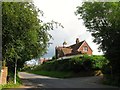
3
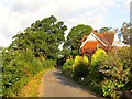
Tott Lane, Hurstpierpoint
Private road that links the B2116 with Image The house on the right is Little Withiel built in the late Victoriasn period.
Image: © Simon Carey
Taken: 7 Aug 2014
0.06 miles
4
Pine Tree Close, Hurstpierpoint
A small cul de sac off Highfield Drive built in the 1960s.
Image: © Simon Carey
Taken: 7 Aug 2014
0.07 miles
5
Cherrington Close, Hurstpierpoint
A small cul de sac off Highfield Drive built in the 1960s.
Image: © Simon Carey
Taken: 7 Aug 2014
0.07 miles
6
Wych House, Hassocks Road, Hurstpierpoint
Built in the last quarter of the 19th century and viewed from the junction of Hassocks Road and St George's Lane.
Image: © Simon Carey
Taken: 13 Jul 2014
0.10 miles
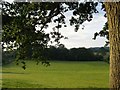
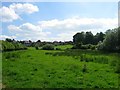
7
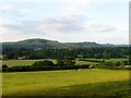
Banky Field
The name of the field according to Hurstpierpoint's 1842 tithe map that has been merged with Image to form a larger unit. Beyond the hedge at the bottom of the slope is Image with Image the large field to the south. Amongst the trees between that field and Wolstonbury Hill is the roof of Danny House and to the right in the far distance is Newtimber Hill.
Image: © Simon Carey
Taken: 7 Aug 2014
0.10 miles
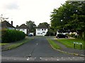
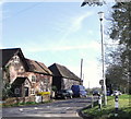
8
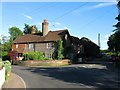
Danny Corner/Randiddles, Hassocks Road, Hurstpierpoint
The house dates back to the 18th century and was formerly Randiddles Farm whose 18th century barn still survives among the shadows in New Way Lane. Danny Corner is on the left, Randiddles to the right next to New Way Lane which heads south to Clayton.
Image: © Simon Carey
Taken: 7 Jun 2014
0.12 miles
10
Banky Field Leg
The name of the field according to Hurspierpoint's 1842 tithe map that lies to the west of Hollow Dyke, south of Banky Field, east of Image and north of Image The houses beyond front onto Hassocks Road, the B2116.
Image: © Simon Carey
Taken: 31 May 2014
0.13 miles