IMAGES TAKEN NEAR TO
South Avenue, HASSOCKS, BN6 9QB
Introduction
This page details the photographs taken nearby to South Avenue, BN6 9QB by members of the Geograph project.
The Geograph project started in 2005 with the aim of publishing, organising and preserving representative images for every square kilometre of Great Britain, Ireland and the Isle of Man.

There are currently over 7.5m images from over14,400 individuals and you can help contribute to the project by visiting https://www.geograph.org.uk
Image Map
Images are licensed for reuse under creativecommons.org/licenses/by-sa/2.0
Notes
- Clicking on the map will re-center to the selected point.
- The higher the marker number, the further away the image location is from the centre of the postcode.
Image Listing (88 Images Found)
Images are licensed for reuse under creativecommons.org/licenses/by-sa/2.0
Image
Details
Distance
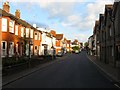
1
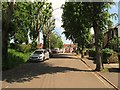
South Avenue, Hurspierpoint
Laid out toward the end of the 19th century when it was initially known as Hill Road. The dead end road heads north to High Street, the B2116.
Image: © Simon Carey
Taken: 31 May 2014
0.02 miles
2
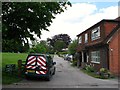
South Lane, Hurstpierpoint
A private road that runs between South Avenue and Pitt Lane that forms the northern boundary of Image To the right is The Old Coach House.
Image: © Simon Carey
Taken: 31 May 2014
0.07 miles
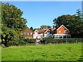
3
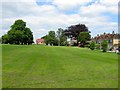
South Avenue Recreation Ground, Hurstpierpoint
Laid out in the first decade of the 20th century on a former field called Hundred needle. according to Hurstpierpoint's 1842 tithe map. The open space is bounded to the north by Image on which the houses to the right, The croft and Little Croft, stand.
Image: © Simon Carey
Taken: 31 May 2014
0.07 miles
4
South Lane
Private road linking South Avenue with Pitt Lane with a recreation ground to the south of the lane.
Image: © Simon Carey
Taken: 10 May 2009
0.07 miles
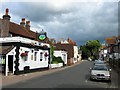
5
High Street, Hurstpierpoint
The eastern end of the village High street just before it becomes Hassocks Road. The houses on the left are located opposite Image
Image: © Simon Carey
Taken: 7 Aug 2014
0.07 miles
6
Torch Christian Holiday and Retreat Centre, Hurstpierpoint
Originally set up as a Sunshine Home for poor and sick women from London it was used as an auxiliary hospital during World War One and taken over by the Church Army in the 1920s. Today it is a Christian holiday centre.
Image: © Simon Carey
Taken: 2 Oct 2015
0.08 miles
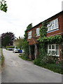
7
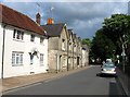
157-175, High Street,Hurstpierpoint
The white building on the left is 157 and was built in the 18th century. Numbers 159-175 are the terrace to its east and was constructed in 1830, a couple of which seem to have been shops sometime in the past.
Image: © Simon Carey
Taken: 13 Jul 2014
0.09 miles
8
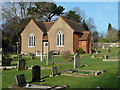
Cemetery chapel, Hurstpierpoint
According to an inset stone, the chapel was built for the Hurstpierpoint Burial Board.
Image: © Robin Webster
Taken: 19 Jan 2011
0.09 miles
9
South Avenue
Looking towards the junction with High Street, the B2116.
Image: © Simon Carey
Taken: 10 May 2009
0.09 miles
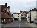
10
The Poacher, High Street, Hurstpierpoint
Formerly the Queens Head Inn at the eastern end of the High Street.
Image: © Simon Carey
Taken: 13 Jul 2014
0.09 miles