IMAGES TAKEN NEAR TO
Holly Mews, High Street, HASSOCKS, BN6 9PW
Introduction
This page details the photographs taken nearby to Holly Mews, High Street, BN6 9PW by members of the Geograph project.
The Geograph project started in 2005 with the aim of publishing, organising and preserving representative images for every square kilometre of Great Britain, Ireland and the Isle of Man.

There are currently over 7.5m images from over14,400 individuals and you can help contribute to the project by visiting https://www.geograph.org.uk
Image Map
Images are licensed for reuse under creativecommons.org/licenses/by-sa/2.0
Notes
- Clicking on the map will re-center to the selected point.
- The higher the marker number, the further away the image location is from the centre of the postcode.
Image Listing (200 Images Found)
Images are licensed for reuse under creativecommons.org/licenses/by-sa/2.0
Image
Details
Distance
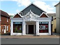
1
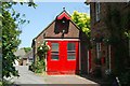
Hurstpierpoint old fire station
Hurstpierpoint old fire station, Holly Mews, High Street, Hurstpierpoint, West Sussex
Image: © Kevin Hale
Taken: 28 Jun 2010
0.01 miles
2
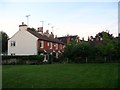
Ribbetts Cottages, High Street, Hurstpierpoint
A 19th century row of cottages set back from the High Street and accessed via Image
Image: © Simon Carey
Taken: 17 Jul 2014
0.02 miles
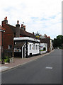
3
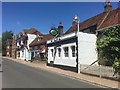
The Poacher
Pub on High Street Hurstpierpoint.
Image: © David Lally
Taken: 13 Jun 2017
0.03 miles
4
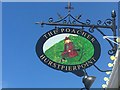
The sign of The Poacher
The current Google Street View shows a different painting on the sign and that is from July last year.
Image: © David Lally
Taken: 13 Jun 2017
0.03 miles
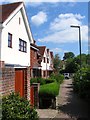
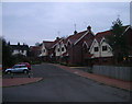
5
Trumpkins, Hurstpierpoint
Small 21st century development located between High Street and Brown Twins Road.
Image: © Simon Carey
Taken: 31 May 2014
0.03 miles
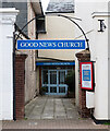
6
Hurstpierpoint : Good News Church
Evangelical church
Image: © Jim Osley
Taken: 25 Mar 2023
0.03 miles
7
The Poacher, High Street
Pub on the main village street in Hurstpierpoint.
Image: © Simon Carey
Taken: 10 May 2009
0.03 miles
8
Ribbetts House, Trinity Road, Hurstpierpoint
Sheltered housing built in 1978 that is squeezed between Trinity Road and High Street.
Image: © Simon Carey
Taken: 31 May 2014
0.03 miles
9
Players Theatre, High Street, Hurstpierpoint
The building dates from the 1820s and was originally a non-conformist chapel until it was converted into a school. Between the wars it was a wine store and was later a general store called graveleys until purchased in 1976 by the Hurstpierpoint Players, a local amateur dramatic society who had formed in 1936 and played at various venues around the village. It opened the following year providing the village with theatre productions ever since.
Image: © Simon Carey
Taken: 31 May 2014
0.04 miles
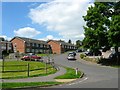
10
Trumpkins
Small housing development between Brown Twins Road car park and the high street. Two of them are already available for letting.
Image: © Simon Carey
Taken: 4 Jan 2009
0.04 miles