IMAGES TAKEN NEAR TO
Mill Lane, HASSOCKS, BN6 9HL
Introduction
This page details the photographs taken nearby to Mill Lane, BN6 9HL by members of the Geograph project.
The Geograph project started in 2005 with the aim of publishing, organising and preserving representative images for every square kilometre of Great Britain, Ireland and the Isle of Man.

There are currently over 7.5m images from over14,400 individuals and you can help contribute to the project by visiting https://www.geograph.org.uk
Image Map
Images are licensed for reuse under creativecommons.org/licenses/by-sa/2.0
Notes
- Clicking on the map will re-center to the selected point.
- The higher the marker number, the further away the image location is from the centre of the postcode.
Image Listing (21 Images Found)
Images are licensed for reuse under creativecommons.org/licenses/by-sa/2.0
Image
Details
Distance
1
Old House
Dating back to the 16th century and the original Naldretts, a name transferred to a newer house built in the first decade of the 20th century which lies a little to the west.
Image: © Simon Carey
Taken: 22 Jul 2014
0.02 miles
2
Footpath 20 Hu passing Naldretts
A large country house SW of Goddards Green.
Image: © Dave Spicer
Taken: 30 Apr 2011
0.07 miles
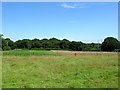
3
Bellows Nose
The name of the field according to Hurstpierpoint's 1842 tithe map. This is the southern part of the former field that lies between Image and Naldretts. See also Image Much of the former farmland was landscaped when Naldretts was constructed during the Edwardian era.
Image: © Simon Carey
Taken: 22 Jul 2014
0.08 miles
4
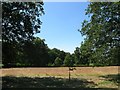
Two Acres
The name of the field according to Hurstpierpoint's 1842 tithe map that lies on the southern side of the drive to Old House.
Image: © Simon Carey
Taken: 22 Jul 2014
0.09 miles
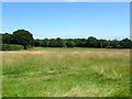
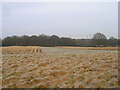
5
Bellows Nose/Copse Field
The name of the fields according to Hurstpierpoint's 1842 tithe map that have been merged to form a larger unit. To the south is the remaining part of Image, whilst to the east is Image, Image is to the west whilst The Gill is the wood at the far end of the field.
Image: © Simon Carey
Taken: 22 Jul 2014
0.10 miles
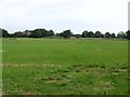
6
Old House Field/Sour Field
The name of the fields according to Hurstpierpoint's 1842 tithe map that have been merged to form a larger unit along with Image to the east. The field is also bounded by Image to the south and Image to the west. Great Wood is visible in the distance. Sour field is located at the far end of the current field.
Image: © Simon Carey
Taken: 22 Jul 2014
0.12 miles
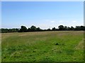
7
Round Head/Copse Field/Three Acres
The name of the fields according to Hurstpierpoint's 1842 tithe map that have been merged together to form a larger unit. Three Acres was in the foreground adjacent to Northend lane whilst Round Head occupied the north west part and Copse Field the north east adjacent to Image The house in the distance to the left is Naldretts.
Image: © Simon Carey
Taken: 25 Jul 2014
0.13 miles
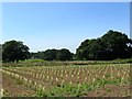
8
Five Acres
The name of the field according to Hurstpierpoint's 1842 tithe map that has been merged with Image to the west to form a larger unit. To the east is Image whilst to the south is Image
Image: © Simon Carey
Taken: 22 Jul 2014
0.13 miles
9
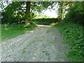
Blackhouse Wood
Viewed from the footpath that links Pookbourne Lane to Mill Lane. Blackhouse was also the former name of Naldretts Farm.
Image: © Simon Carey
Taken: 4 Jan 2009
0.14 miles
10
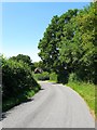
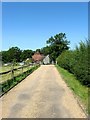
Mill Lane
A narrow lane that runs west from Cuckfield Road joining Pomper Lane whereupon it becomes Northend Lane. Northend Cottage is the house in view.
Image: © Simon Carey
Taken: 22 Jul 2014
0.14 miles