IMAGES TAKEN NEAR TO
Meadow View, HASSOCKS, BN6 9GB
Introduction
This page details the photographs taken nearby to Meadow View, BN6 9GB by members of the Geograph project.
The Geograph project started in 2005 with the aim of publishing, organising and preserving representative images for every square kilometre of Great Britain, Ireland and the Isle of Man.

There are currently over 7.5m images from over14,400 individuals and you can help contribute to the project by visiting https://www.geograph.org.uk
Image Map
Images are licensed for reuse under creativecommons.org/licenses/by-sa/2.0
Notes
- Clicking on the map will re-center to the selected point.
- The higher the marker number, the further away the image location is from the centre of the postcode.
Image Listing (44 Images Found)
Images are licensed for reuse under creativecommons.org/licenses/by-sa/2.0
Image
Details
Distance
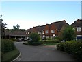
1

Meadow View, Sayers Common
Small cul de sac off Reeds Lane built around 2006 on the site of a former depot.
Image: © Simon Carey
Taken: 17 Aug 2014
0.01 miles
2
New fencing for field and path boundary near Reed's Lane Sayers Common
Image: © Dave Spicer
Taken: 6 Jun 2010
0.05 miles
3

Industrial units on Reed's Lane Sayers Common
Image: © Dave Spicer
Taken: 6 Jun 2010
0.05 miles
4
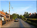
Reeds Lane, Sayers Common
The highway links London Road at Sayers Common with Twineham Lane at High Cross. On the right are Kinglsnad Cottages built in the late 19th century for workers in the old brick and tile works which was located behind the cottages next to the wood called furzefield.
Image: © Simon Carey
Taken: 31 Jul 2014
0.06 miles
5
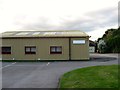
King Business Centre, Reeds Lane, Sayers Common
A small estate of business units at the western end of Sayers Common though officially in the parish of Albourne.
Image: © Simon Carey
Taken: 17 Aug 2014
0.07 miles
6
Kingsland Cottages, Reeds Lane, Sayers Common
Built in the late 19th century possibly for workers for the old brick and tile works which was once located to the rear of the properties. Beyond Reeds Lane heads towards its junction with London Road passing by what was the original green called Sayers Common.
Image: © Simon Carey
Taken: 17 Aug 2014
0.07 miles
7
Osborn Close, Sayers Common
Small cul de sac off Reeds Lane built around 2002.
Image: © Simon Carey
Taken: 17 Aug 2014
0.07 miles
8
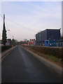
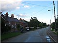
Reeds Lane
Minor road linking London Road, the B2118, with Henfield Road, the B2116, at High Cross. Major mains work is occurring hence the temporary cabins on the right.
Image: © Simon Carey
Taken: 4 Jan 2009
0.07 miles
9
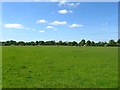
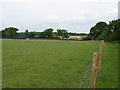
Bellows Nose Field
The name of the field according to Albourne's 1839 tithe map that lies to the north of Image and south of Reeds Lane. The field has been named after its shape, resembling a bellows used for fires.
Image: © Simon Carey
Taken: 3 May 2014
0.10 miles
10
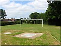
Playing Field, Sayers Common
Lying immediately to the north of Reeds Lane and indeed once part of Sayers Common, an open area of ground that existed here well before the houses arrived.
Image: © Simon Carey
Taken: 31 Jul 2014
0.11 miles