IMAGES TAKEN NEAR TO
The Grange, HASSOCKS, BN6 9FD
Introduction
This page details the photographs taken nearby to The Grange, BN6 9FD by members of the Geograph project.
The Geograph project started in 2005 with the aim of publishing, organising and preserving representative images for every square kilometre of Great Britain, Ireland and the Isle of Man.

There are currently over 7.5m images from over14,400 individuals and you can help contribute to the project by visiting https://www.geograph.org.uk
Image Map
Images are licensed for reuse under creativecommons.org/licenses/by-sa/2.0
Notes
- Clicking on the map will re-center to the selected point.
- The higher the marker number, the further away the image location is from the centre of the postcode.
Image Listing (50 Images Found)
Images are licensed for reuse under creativecommons.org/licenses/by-sa/2.0
Image
Details
Distance
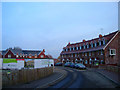
1
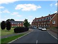
The Grange, Hurstpierpoint
A new development from 2008, see Image, and now named after a house that lies behind me to the south now known as Ladymead. The development was built on a couple of former fields called Box House Field and Lower Acres according to Hurstpierpoint's 1842 tithe map.
Image: © Simon Carey
Taken: 31 May 2014
0.04 miles
2
Play area and new residential estate at West Town
Image: © Dave Spicer
Taken: 6 Jun 2010
0.04 miles
3
Claremont Park
New development from the previous year off Albourne Road. So new it isn't marked on the map yet.
Image: © Simon Carey
Taken: 4 Jan 2009
0.05 miles
4
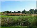
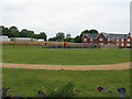
Box House Mead
The name of the field according to Hurstpierpoint's 1842 tithe map that is bounded by Image to the north, Image to the east, Image to the south and Langton Lane to the west. Part of the fields adjacent to The grange have been landscaped including a pond beyond the reeds in the foreground.
Image: © Simon Carey
Taken: 17 Jul 2014
0.06 miles
5
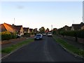
Orchard Way, Hurstpierpoint
The name of a cul de sac that runs north from Albourne Road, the B2116. Originally a couple of fields called Rick Plot and West Pease Croft according to Hurstpierpoint's 1842 tithe map. The small estate was built after the Second World War.
Image: © Simon Carey
Taken: 6 Jul 2014
0.07 miles
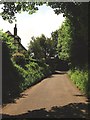
6
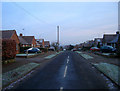
Orchard Way
Part of the West Town suburb of Hurstpiepoint is this post war cul-de-sac. Taken from the junction with Albourne Road, the B2116.
Image: © Simon Carey
Taken: 4 Jan 2009
0.08 miles
7
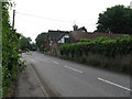
Paddock Cottage, Albourne Road, Hurstpierpoint
Originally part of Paddock Diary then Grange Farm prior to its move southwards down Bullfinch Lane. The building was rebuilt and converted sometime in the first decade of the 20th century.
Image: © Simon Carey
Taken: 31 May 2014
0.10 miles
8
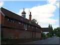
Box House Farm, Langton Lane, West Town
The farmhouse dates from at least the 17th century.
Image: © Simon Carey
Taken: 31 May 2014
0.10 miles