IMAGES TAKEN NEAR TO
Church Lane, HASSOCKS, BN6 9BZ
Introduction
This page details the photographs taken nearby to Church Lane, BN6 9BZ by members of the Geograph project.
The Geograph project started in 2005 with the aim of publishing, organising and preserving representative images for every square kilometre of Great Britain, Ireland and the Isle of Man.

There are currently over 7.5m images from over14,400 individuals and you can help contribute to the project by visiting https://www.geograph.org.uk
Image Map
Images are licensed for reuse under creativecommons.org/licenses/by-sa/2.0
Notes
- Clicking on the map will re-center to the selected point.
- The higher the marker number, the further away the image location is from the centre of the postcode.
Image Listing (59 Images Found)
Images are licensed for reuse under creativecommons.org/licenses/by-sa/2.0
Image
Details
Distance
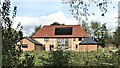
1
Wellcroft Cottages, Church Lane, Albourne
The cottages were constructed between the wars and named after the field they were built in.
Image: © Simon Carey
Taken: 25 May 2014
0.01 miles
2
Wellcroft Cottages
Viewed from the footpath to that runs from Hazeldens Nurseries to Albourne church.
Image: © Simon Carey
Taken: 10 May 2009
0.01 miles
3
Gulls - and view SSE towards Wolstonbury Hill
Image: © Ian Hawfinch
Taken: 14 Oct 2020
0.05 miles
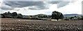
5

Town Mead/Little Newer/The Newer
The name of the fields according to Albourne's 1839 tithe map that have been joined together to make a larger unit. Town mead was in the foreground whilst Little Newer was to the right at the far end of the field with The newer to the left adjacent to Church Lane. Just visible on that side are Wellcroft Cottages.
Image: © Simon Carey
Taken: 3 May 2014
0.07 miles
6
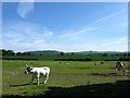
Spring Mead
The name of the field according to Albourne's 1839 tithe map. The cow statue has a twin at the entrance to Albourne Primary School whilst beyond the large field is an amalgamation of Image and Image whilst visible to the right is Image Newtimber Hill and the northern side of Devils Dyke provides the backdrop.
Image: © Simon Carey
Taken: 25 May 2014
0.07 miles
7

Dean Mead
The name of the field according to Albourne's 1839 tithe map that lies to the north of Image and to the immediate south of Image During the 1950s the field was used as the village's cricket ground until the club merged with neighbouring Sayers Common and moved there. Wellcroft Cottages can be seen in the distance.
Image: © Simon Carey
Taken: 3 May 2014
0.08 miles
8
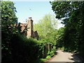
Spring Cottage, Church Lane, Albourne
Located to the west of the junction with The Street and dating from the early 17th century.
Image: © Simon Carey
Taken: 31 May 2014
0.11 miles
9
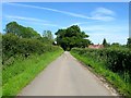
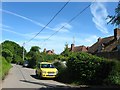
Church Lane
Heading eastward back to the village from the church. The fields either side of the hedges are Image to the left and Image to the right whilst the cottages in the distance are Nulli Secundus and Bowleys.
Image: © Simon Carey
Taken: 25 May 2014
0.12 miles
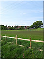
10
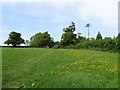
Field next to Church Lane
Taken from the footpath that runs from Hazeldens Nurseries to Albourne church. The hedge at the top of the slope marks the course of the lane.
Image: © Simon Carey
Taken: 10 May 2009
0.12 miles