IMAGES TAKEN NEAR TO
South Street, HASSOCKS, BN6 8UQ
Introduction
This page details the photographs taken nearby to South Street, BN6 8UQ by members of the Geograph project.
The Geograph project started in 2005 with the aim of publishing, organising and preserving representative images for every square kilometre of Great Britain, Ireland and the Isle of Man.

There are currently over 7.5m images from over14,400 individuals and you can help contribute to the project by visiting https://www.geograph.org.uk
Image Map
Images are licensed for reuse under creativecommons.org/licenses/by-sa/2.0
Notes
- Clicking on the map will re-center to the selected point.
- The higher the marker number, the further away the image location is from the centre of the postcode.
Image Listing (243 Images Found)
Images are licensed for reuse under creativecommons.org/licenses/by-sa/2.0
Image
Details
Distance
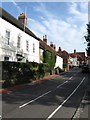
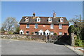
1
South Street, Ditchling
South Street in the village of Ditchling, in East Sussex.
Image: © Malc McDonald
Taken: 13 Apr 2019
0.01 miles
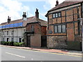
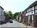
3
South Street
The B2112 heads south towards Brighton, originally via Ditchling Beacon then from 1820 via Clayton. The ivy covered house near the centre was the former home of Sir Frank Brangwyn, artist and etcher. The parked cars on this street can often cause tailbacks though does provide a good method of slowing traffic down as it travels through the village.
Image: © Simon Carey
Taken: 19 Aug 2009
0.02 miles
4
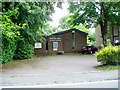
Emmanuel Chapel
This former mission hall, opened in the early 20th century, is one of three extant non-Anglican places of worship in Ditchling.
Image: © Peter Holmes
Taken: 18 Jul 2009
0.03 miles
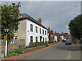
5
South Street, Ditchling
The village of Ditchling lies in the South Downs National Park. The South Downs ridge is visible in the distance.
Image: © Malc McDonald
Taken: 26 May 2013
0.03 miles
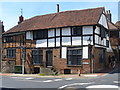
6
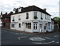
Pruden & Smith, South Street
Goldsmiths and jewellers occupying the shop on the south east corner of Ditchling crossroads. The building actually contains three shops including Pruden & Smith, another to its left on Lewes Road which I neglected to remember and the pharmacy to the right in South Street. The building dates from the 1870s and was built on the site of the former Ditchling & Westmeston Parish Workhouse which closed its doors in 1873. To the left is Tudor Close one of the oldest buildings in Ditchling being a timber framed hall house refronted with brick and tile hanging dating back to the late 15th century.
Image: © Simon Carey
Taken: 23 Aug 2009
0.03 miles
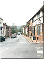
7
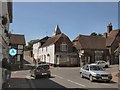
Crossroads in Ditchling
at the junction of South Street, High Street and West Street with St Margaret of Antioch church in the background
Image: © Paul Gillett
Taken: 10 Jul 2010
0.03 miles
9
In the centre of Ditchling
The centre of Ditchling is a busy crossroads and it is often difficult to take photographs without cars getting in the way. This is on the corner of South Street and West Street.
Image: © Marathon
Taken: 1 Aug 2015
0.04 miles