IMAGES TAKEN NEAR TO
Farm Lane, HASSOCKS, BN6 8UN
Introduction
This page details the photographs taken nearby to Farm Lane, BN6 8UN by members of the Geograph project.
The Geograph project started in 2005 with the aim of publishing, organising and preserving representative images for every square kilometre of Great Britain, Ireland and the Isle of Man.

There are currently over 7.5m images from over14,400 individuals and you can help contribute to the project by visiting https://www.geograph.org.uk
Image Map (Loading...)


Getting Data...Please wait
Leaflet Map data © OpenStreetMap
Images are licensed for reuse under creativecommons.org/licenses/by-sa/2.0
Notes
- Clicking on the map will re-center to the selected point.
- The higher the marker number, the further away the image location is from the centre of the postcode.
Image Listing (76 Images Found)
Images are licensed for reuse under creativecommons.org/licenses/by-sa/2.0
Image
Details
Distance
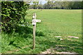
4
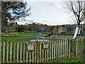
Play area, Ditchling Recreation Ground
The recreations of cycling and golf practice are not allowed in the recreation ground, according to the signs. Is that all?
Image: © Robin Webster
Taken: 14 Dec 2010
0.05 miles
6
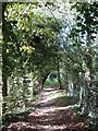
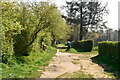
Footpath from Farm Lane
Heading north to join a number of other footpaths near modern day Stoneywish Park. The old field boundary still exists to the left.
Image: © Simon Carey
Taken: 4 Sep 2009
0.06 miles
7
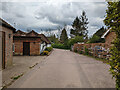
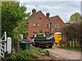
Farm Lane, Ditchling East End
Public footpath Ditchling 38, so presumably a private road.
Image: © Robin Webster
Taken: 19 Apr 2022
0.07 miles
9
East End Lane, Ditchling
Ditchling is a village in East Sussex, within the South Downs National Park.
Image: © Malc McDonald
Taken: 26 May 2013
0.08 miles
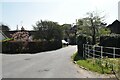
10
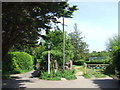
Pardons, East End Lane
At the junction of the lane and an old east-west route that is now a footpath. The house dates from the 17th century.
Image: © Simon Carey
Taken: 4 Sep 2009
0.09 miles