IMAGES TAKEN NEAR TO
Brangwyn's Acre, HASSOCKS, BN6 8UG
Introduction
This page details the photographs taken nearby to Brangwyn's Acre, BN6 8UG by members of the Geograph project.
The Geograph project started in 2005 with the aim of publishing, organising and preserving representative images for every square kilometre of Great Britain, Ireland and the Isle of Man.

There are currently over 7.5m images from over14,400 individuals and you can help contribute to the project by visiting https://www.geograph.org.uk
Image Map
Images are licensed for reuse under creativecommons.org/licenses/by-sa/2.0
Notes
- Clicking on the map will re-center to the selected point.
- The higher the marker number, the further away the image location is from the centre of the postcode.
Image Listing (208 Images Found)
Images are licensed for reuse under creativecommons.org/licenses/by-sa/2.0
Image
Details
Distance
1
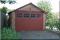
Ditchling old fire station 3
Ditchling old fire station 3, Brangwyn's Acre, Ditchling, West Sussex. The third station in the town was erected next to the local village school but a wealthy landowner who lived in a nearby townhouse objected to the sight of the fire station roof seen from his windows, so he paid for it to be removed to farmland he owned. At that time it had white doors. It was then moved to its final resting place in Brangwyn's Acre.
Image: © Kevin Hale
Taken: 28 Jun 2010
0.03 miles
2
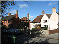
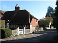
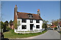
Cherry Tree Cottage, East End Lane
Is the cottage on the right which dates from the late 16th century.Mulberry Cottage to the left dates from the 17th century. East End Lane was the original main village street until it realigned during the medieval period and remained the eastern route out of the village until 1810 when a new turnpike was built to the south that is now currently the B2116.
Image: © Simon Carey
Taken: 4 Nov 2009
0.04 miles
4
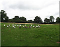
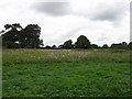
Great Sharface
The name of the field according to the 1843 tithe map. The geese were making an unholy racket which I could hear nearly two fields away until I walked through the field when they decided to be quiet and mill around. When I exited the field the racket started up again.
Image: © Simon Carey
Taken: 16 Aug 2009
0.08 miles
5
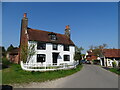
Walnut Tree Cottage, East End Lane
Dating from the late 16th century with some 18th century modifications. East End Lane was main eastward route out of the village until a turnpike was built to the south that is now the current B2116.
Image: © Simon Carey
Taken: 4 Nov 2009
0.08 miles
6
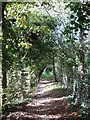
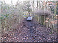
Footpath from Farm Lane
Heading north to join a number of other footpaths near modern day Stoneywish Park. The old field boundary still exists to the left.
Image: © Simon Carey
Taken: 4 Sep 2009
0.09 miles
8
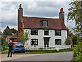
Pardons, East End Lane, Ditchling
A grade II listed building, 17th century with 18th century brick front.
Image: © Robin Webster
Taken: 19 Apr 2022
0.10 miles
10
Sheep Hag
The name of the southern part of this field according to the 1843 tithe map which has joined with another to the north called Little Sharface.
Image: © Simon Carey
Taken: 16 Aug 2009
0.10 miles