IMAGES TAKEN NEAR TO
Lewes Road, HASSOCKS, BN6 8TT
Introduction
This page details the photographs taken nearby to Lewes Road, BN6 8TT by members of the Geograph project.
The Geograph project started in 2005 with the aim of publishing, organising and preserving representative images for every square kilometre of Great Britain, Ireland and the Isle of Man.

There are currently over 7.5m images from over14,400 individuals and you can help contribute to the project by visiting https://www.geograph.org.uk
Image Map
Images are licensed for reuse under creativecommons.org/licenses/by-sa/2.0
Notes
- Clicking on the map will re-center to the selected point.
- The higher the marker number, the further away the image location is from the centre of the postcode.
Image Listing (246 Images Found)
Images are licensed for reuse under creativecommons.org/licenses/by-sa/2.0
Image
Details
Distance

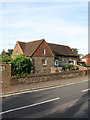
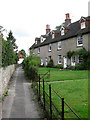
2
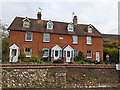
Sunnyside 1898, Ditchling
Four cottages on Lewes Road.
Image: © Robin Webster
Taken: 19 Apr 2022
0.01 miles
3
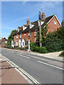
Sunnysides, Lewes Road
Terraced cottages built on the modern day B2116 in 1888.
Image: © Simon Carey
Taken: 23 Aug 2009
0.01 miles
4
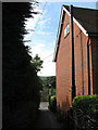
Air Vent, The Twitten
A Victorian air vent built when the sewers were laid next to Sunnysides just off Lewes Road, the B2116. The only surviving one left in the village though the bases of two others remain.
Image: © Simon Carey
Taken: 23 Aug 2009
0.02 miles
6
Ditchling Village Hall
On Lewes Road, the B2116, and constructed in 1920 on the site of Eastfield House.
Image: © Simon Carey
Taken: 19 Aug 2009
0.03 miles
7
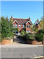
Meadowcroft, Lewes Road, Ditchling
These semi-detached houses were built during the 1890s and are now numbered 31 and 33. The latter has been known as Meadowcroft for quite some time and was rented out in 1914 for use as an auxiliary hospital with a capacity for 15 recovering soldiers, by the local vicar who put his wife and daughter in charge. The records for the home during the conflict survive and are kept at the East Sussex Records Office. After the war the building reverted to residential use.
Image: © Simon Carey
Taken: 2 Oct 2015
0.03 miles
8
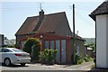
Ditchling old fire station 4
Ditchling old fire station 4, Lewes Road, Ditchling, West Sussex
Image: © Kevin Hale
Taken: 28 Jun 2010
0.03 miles
9
The Twitten
Twitten is the Sussex word for narrow alley and this one links Lewes Road to East End Lane and includes this row of cottages set at an angle to the pathway.
Image: © Simon Carey
Taken: 16 Aug 2009
0.03 miles