IMAGES TAKEN NEAR TO
St. Helena Lane, HASSOCKS, BN6 8SD
Introduction
This page details the photographs taken nearby to St. Helena Lane, BN6 8SD by members of the Geograph project.
The Geograph project started in 2005 with the aim of publishing, organising and preserving representative images for every square kilometre of Great Britain, Ireland and the Isle of Man.

There are currently over 7.5m images from over14,400 individuals and you can help contribute to the project by visiting https://www.geograph.org.uk
Image Map
Images are licensed for reuse under creativecommons.org/licenses/by-sa/2.0
Notes
- Clicking on the map will re-center to the selected point.
- The higher the marker number, the further away the image location is from the centre of the postcode.
Image Listing (21 Images Found)
Images are licensed for reuse under creativecommons.org/licenses/by-sa/2.0
Image
Details
Distance
1
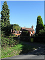
Kidds Farm
On St Helena Lane and originally built in the waste ground between the highway and the Streat-Westmeston parish border. I believe the original is on the left and has been extended somewhat probably before the era of planning controls.
Image: © Simon Carey
Taken: 31 Aug 2009
0.01 miles
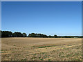
2
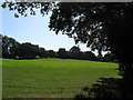
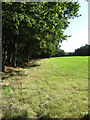
Three Acres
The name of the field according to the 1838 tithe map and formerly part of Streat Common that was enclosed in the early 17th century. It has now been enlarged to include its neighbour to the east called Long Three Acres to create an L shape field behind Kidds Farm which lies beyond the trees in the distance.
Image: © Simon Carey
Taken: 31 Aug 2009
0.08 miles
3
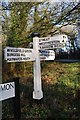
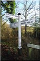
Old Direction Sign - Signpost by Middleton Common Lane, Westmeston parish
Black iron cap finial - 3 arms; East Sussex wood by the UC road, in parish of Westmeston (Lewes District), junction of St Helena Lane with Middleton Common Lane, on verge at junction, North side of road.
Surveyed
Milestone Society National ID: SX_TQ3517
Image: © Milestone Society
Taken: Unknown
0.10 miles
4
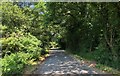
Streat Lane near Gallops Farm
Looking North towards the junction with St Helena Lane.
Image: © Chris Thomas-Atkin
Taken: 7 Jul 2018
0.12 miles
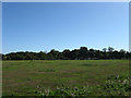
5
Long Three Acres
The name of the field according to the 1838 tithe map and formerly part of Streat Common that was enclosed in the early 17th century. The field has now been enlarged to include another to the west, Three Acres to form an L shape field behind Kidds Farm.
Image: © Simon Carey
Taken: 31 Aug 2009
0.14 miles
6
Old Direction Sign - Signpost by Hundred Acre Lane, Westmeston parish
Black iron cap finial - 3 arms; East Sussex wood by the UC road, in parish of Westmeston (Lewes District), junction of Hundred Acre Lane with Middleton Common Lane, on verge at junction, South side of road.
Surveyed
Milestone Society National ID: SX_TQ3417A
Image: © Milestone Society
Taken: Unknown
0.14 miles
7
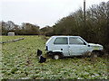
Dead Panda found in Sussex field!
Near the footpath starting north from Middleton Common Lane.
Image: © Robin Webster
Taken: 17 Dec 2010
0.16 miles
8
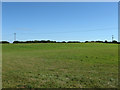
Great Mill Common
The name of the field according to the 1838 tithe map and formerly part of Middleton Common that was enclosed in the mid 17th century. The current large field was once two Great and Little Mill Common and the rise in the ground plus the name suggests the location of a former mill. Viewed from the footpath that links The Potteries with Hundred Acre Lane.
Image: © Simon Carey
Taken: 31 Aug 2009
0.17 miles
9
Furze Field
The name of the field according to the 1838 tithe map and formerly part of Streat Common that was enclosed in the early 17th century. The field has now been enlarged to include three others, Five Acres, Four Acres and Great Barn Field that extend down the hill to the east.
Image: © Simon Carey
Taken: 31 Aug 2009
0.17 miles
10
New Field near Huntswood
The 1:50000 OS map has this down as woodland but the current 1:25000 does not though an older map dating from 1975 of the same scale has this area marked down as Hunt's Wood. The woodland has gone but the name lives on in the house.
Image: © Simon Carey
Taken: 31 Aug 2009
0.18 miles