IMAGES TAKEN NEAR TO
Streat Lane, HASSOCKS, BN6 8RS
Introduction
This page details the photographs taken nearby to Streat Lane, BN6 8RS by members of the Geograph project.
The Geograph project started in 2005 with the aim of publishing, organising and preserving representative images for every square kilometre of Great Britain, Ireland and the Isle of Man.

There are currently over 7.5m images from over14,400 individuals and you can help contribute to the project by visiting https://www.geograph.org.uk
Image Map (Loading...)


Getting Data...Please wait
Leaflet Map data © OpenStreetMap
Images are licensed for reuse under creativecommons.org/licenses/by-sa/2.0
Notes
- Clicking on the map will re-center to the selected point.
- The higher the marker number, the further away the image location is from the centre of the postcode.
Image Listing (27 Images Found)
Images are licensed for reuse under creativecommons.org/licenses/by-sa/2.0
Image
Details
Distance
1
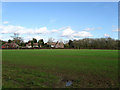
Friends Field
The name of the field according to the 1838 tithe map. Sandpit Cottages are at the end of the field.
Image: © Simon Carey
Taken: 4 Nov 2009
0.03 miles
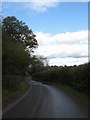
2
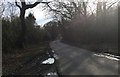
Streat Lane
Streat Lane near Blackberry Farm.
Image: © Chris Thomas-Atkin
Taken: 14 Mar 2018
0.04 miles
3
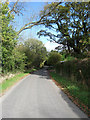
Streat Lane
The lane provides the backbone to the parish of Streat linking the B2116 in the south to Middleton Common Road in the north. The entrance to Sandpit Cottages can just be made out.
Image: © Simon Carey
Taken: 4 Nov 2009
0.04 miles
4
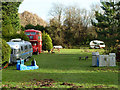
A peep into Blackberry Wood
This claims to be "the coolest campsite in the UK". Its website is certainly quite cool. The view appears to be the open area, with vehicles on view available for camping. The wood is beyond, with camping sites dotted around. Across the other side of Streat Lane is 'Blackberry Fields', presumably all part of the same concern.
Image: © Robin Webster
Taken: 14 Dec 2010
0.04 miles
5
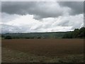
Friends Field
The name of the field according to the 1838 tithe map. The northern scarp slope of the South Downs is in the distance whilst threatening grey clouds loom above.
Image: © Simon Carey
Taken: 13 Sep 2009
0.04 miles
6
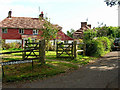
Sandpit Cottages, Streat Lane
Built originally for workers in the sand pit on the other side of Streat Lane. The view looks east.
Image: © Simon Carey
Taken: 24 Sep 2005
0.06 miles
7
The Hospital
The name of this section of the current field according to the 1838 tithe map though Yeakell & Gardner's 1783 map has it as a section of the highway. Now part of a field called Streat Brooks.
Image: © Simon Carey
Taken: 13 Sep 2009
0.07 miles
8
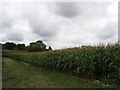
Sand Pit Field
The name of the field according to the 1838 tithe map. Between the ridge in the distance and the foot of the South Downs is a small geological strip of land known as the greensand which contains sandy soils and was often quarried for sand, and still is near Storrington. A disused sandpit lies on the western side of Streat Lane nearby and this one may well have contained another old pit which was filled in and reverted to agricultural use.
Image: © Simon Carey
Taken: 13 Sep 2009
0.11 miles
9
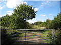
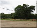
Track off Streat Lane
The sign says "Blackberry Fields".
Image: © Oast House Archive
Taken: 17 Oct 2010
0.12 miles
10
Streat Lane
The main lane of the parish which extends from the B2116 in the south to Middleton Common Road in the north. Here it crosses a small unnamed stream with Brocks Wood to the left.
Image: © Simon Carey
Taken: 4 Nov 2009
0.14 miles