IMAGES TAKEN NEAR TO
Deer Park, HENFIELD, BN5 9QR
Introduction
This page details the photographs taken nearby to Deer Park, BN5 9QR by members of the Geograph project.
The Geograph project started in 2005 with the aim of publishing, organising and preserving representative images for every square kilometre of Great Britain, Ireland and the Isle of Man.

There are currently over 7.5m images from over14,400 individuals and you can help contribute to the project by visiting https://www.geograph.org.uk
Image Map
Images are licensed for reuse under creativecommons.org/licenses/by-sa/2.0
Notes
- Clicking on the map will re-center to the selected point.
- The higher the marker number, the further away the image location is from the centre of the postcode.
Image Listing (40 Images Found)
Images are licensed for reuse under creativecommons.org/licenses/by-sa/2.0
Image
Details
Distance
1
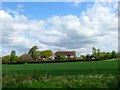
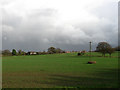
Parsonage Farm
Current house appears to date from the 1950s though the site is much older. Much of the land north of Henfield up to Chess Brook was once part of the medieval Henfield Park, a deer park owned by the Bishop of Chichester, that was disparked in the 16th century. The farm is believed to stand on the site of the former lodge
Image: © Simon Carey
Taken: 18 Apr 2017
0.02 miles
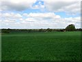
3
Parsonage Farm
Viewed from the footpath that runs along the northern edge of Henfield with views over the High Weald beyond.
Image: © Simon Carey
Taken: 29 Nov 2009
0.04 miles
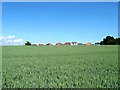
4
Henfield, Sussex - view ENE towards Parsonage Farm
Image: © Ian Hawfinch
Taken: 9 Feb 2020
0.05 miles
5
Parsonage Farm
Viewed from the Downs Link with the new estate of Deer Park just on the brow of the hill.
Image: © Simon Carey
Taken: 29 Nov 2009
0.06 miles
6
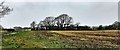
Little Lodge Field (1)
The name of the field according to Henfield's 1844 tithe map that is bounded by Henfield to the south, a new housing estate to the east, see Image, Image to the west and Image to the north. The latter was once the site of a medieval hunting lodge for Henfield Park which kept deer for its owner, the Bishop of Chichester. See also Image for a view looking east.
Image: © Simon Carey
Taken: 18 Apr 2017
0.09 miles
7
Henfield, Sussex - view east towards Parsonage Farm and Deer Park
Image: © Ian Hawfinch
Taken: 9 Feb 2020
0.11 miles
8
Little Lodge Field (2)
The name of the field according to Henfield's 1844 tithe map. This another view of Image this time looking east towards the recently built Deer Park estate. One wonders how long before this field is developed.
Image: © Simon Carey
Taken: 1 Jun 2017
0.14 miles
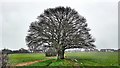
9
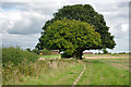
Trees by the footpath
This well-used path connects the Downs Link trail with the northern residential area of Henfield. The distant hay barn belongs to Parsonage Farm.
Image: © Robin Webster
Taken: 25 Sep 2010
0.14 miles
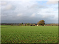
10
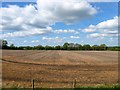
Mow Clear
The name of the field according to Henfield's 1844 tithe map that is located between Image to the west and the new housing development to the east. In all likelihood the field will probably be developed sometime in the future.
Image: © Simon Carey
Taken: 18 Apr 2017
0.15 miles