IMAGES TAKEN NEAR TO
Woolvens Row, Furners Lane, HENFIELD, BN5 9HU
Introduction
This page details the photographs taken nearby to Woolvens Row, Furners Lane, BN5 9HU by members of the Geograph project.
The Geograph project started in 2005 with the aim of publishing, organising and preserving representative images for every square kilometre of Great Britain, Ireland and the Isle of Man.

There are currently over 7.5m images from over14,400 individuals and you can help contribute to the project by visiting https://www.geograph.org.uk
Image Map
Images are licensed for reuse under creativecommons.org/licenses/by-sa/2.0
Notes
- Clicking on the map will re-center to the selected point.
- The higher the marker number, the further away the image location is from the centre of the postcode.
Image Listing (269 Images Found)
Images are licensed for reuse under creativecommons.org/licenses/by-sa/2.0
Image
Details
Distance
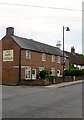
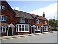
3
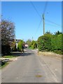
Furners Lane, Henfield
Once a medieval highway that linked Henfield to Hurstpierpoint via Albourne now a narrow country lane used for local access that ends for vehicular traffic at Bilsborough Barn. The view looks back to the junction with High Street.
Image: © Simon Carey
Taken: 9 Apr 2017
0.01 miles
4
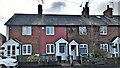
North Cottages, Furners Lane, Henfield
A small terrace of three dwellings that were not marked on Henfield's 1844 tithe map but do appear on the 1875-76 OS map. The junction with high Street is beyond.
Image: © Simon Carey
Taken: 9 Apr 2017
0.01 miles
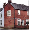
5
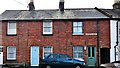
Old Dairy Cottages, High Street, Henfield
The cottages date from the 19th century and were a mixture of dwellings and shops later becoming a set of offices called Aviation House. In 2005 the premises were vacated and converted back into dwellings and given their current name. Located on the corner of Furners Lane.
Image: © Simon Carey
Taken: 23 Jul 2017
0.02 miles
6
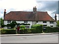
Redbarn Cottage/St Antony's Cottage, High Street, Henfield
St Antony's Cottage on the right was built around 1390 as a medieval hall house. Redbarn Cottage on the left was added in the 16th century.
Image: © Simon Carey
Taken: 23 Jul 2017
0.02 miles
7
Henfield, Sussex - a ghost sign
I'm not sure whether this really qualifies as a ghost sign, since it has clearly been repainted.
Image: © Ian Hawfinch
Taken: 10 Jan 2014
0.03 miles
8
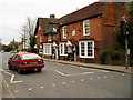
The White Hart, High Street (A281)
An interesting 16th century coaching inn used by the London to Brighton coach for a change of horses and was frequented by the local tanners in the 17th century.
Image: © Peter Holmes
Taken: 18 Mar 2008
0.03 miles
10
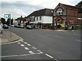
Henfield High Street
Henfield is a large village and civil parish in the Horsham District of West Sussex, http://en.wikipedia.org/wiki/Henfield
Image: © Paul Gillett
Taken: 8 Aug 2009
0.03 miles